1 Feb 2024
Additional bus journey time information
Feedback was received at the 16 January Cabinet meeting in relation to reviewing more information on bus journey times through Portswood Broadway.
The following information found here comes from the Council’s realtime bus information system and shows a comparison between the timetable running time and the actual running time of a bus service through Portswood Broadway on a typical day.
The information also shows the hourly traffic volume of vehicles on Portswood Broadway.
8 January 2024
Phase 2 consultation results
Thank you to everyone who shared their views during the second phase of consultation. The full Phase 2 consultation report can be found below:
Phase 2 scrutiny report can be found here:
OSMC (Overview and Scrutiny Management Committee) report
The consultation received 1,371 submissions and with 60% of respondents saying that it will make Portswood a more attractive area.
We have taken on board the feedback and the recommendation going to Cabinet on the 16 January is that the scheme will be amended as follows:
- It is proposed to have a part time restriction on the bus/taxi/cycle only section of road – 7am to 10am, and 4pm to 7pm. This will allow access to all vehicles outside of these times and emergency service vehicles will be exempt from the restriction.
- Ongoing engagement with local businesses via the Portswood Business Engagement Forum.
- The scheme will be introduced on a trial basis initially for six months to assess the impact of limiting through traffic in the area.
- A community co-design panel to be established to help shape the trial and address issues that were raised in the consultation responses, such as access for people with mobility issues and impacts on businesses.
- The length of the bus/taxi/cycle only section of road will be reduced to be from Westridge Road to St Denys Road spur (near Trago Lounge)
Phase 1 consultation results
In November 2022 we conducted Phase 1 of the Portswood Project consultation.
This has shown that there is support for the scheme with many people wanting better access to sustainable transport such as walking, cycling and public transport, introduction of green space and a more attractive Broadway. The consultation has also shown there are concerns and areas where people want additional information about the scheme.
Thank you to everyone who shared their views during the first phase of consultation. The full Phase 1 consultation report can be found below:
- Portswood Consultation Questionnaire Results Analysis (Appendix A)
- Portswood Corridor Consultation Analysis of Comments (Appendix B)
Phase 1 scrutiny report can be found here:
Areas of concern
Here is more detailed information about the areas of concern, where additional information has been requested, and how we are working to address them.
1. Impact on Local Roads
As part of Phase 1 of consultation in November 2022 and at the Overview and Scrutiny Management Committee meeting in February 2023, the council was asked to provide updated traffic counts and modelling data for the 2nd phase.
In April 2023*, council officers commissioned additional traffic counts by setting up sensors across the Portswood area.
Officers then commissioned an assessment of traffic movements, to record existing flows along with the predicted impact of the installation of a bus gate at Portswood Broadway and the impact the introduction of an Active Travel Zone (ATZ) would have (if the community wishes to have one – to be decided in community co-design).
Traffic modelling has been undertaken to assess the impact of the Portswood Broadway proposals. This looked at traffic rerouting locally within the Broadway and Thomas Lewis Way area and to other routes further away including roads that are not shown on the maps. The roads not shown, such as The Avenue, Burgess Road and Bassett Green Road, would be expected to see the remaining traffic redistributed to them. This is not anticipated to have a significant impact on these roads.
This is considered a worse case scenario as the modelling does not take into account any likely transport mode shift to sustainable travel which would further reduce impacts.
*Correction: traffic counts were carried out in March 2023 but were processed by officers in April 2023.
ATZ Traffic modelling: vehicles per 24 hours (both directions)
Existing Levels, April 2023*: This shows the existing levels of traffic flowing through the area on a normal weekday in April* (figures are number of vehicles per day in a 24 hour period on the road).
*Correction: traffic counts were carried out in March 2023 but were processed by officers in April 2023.
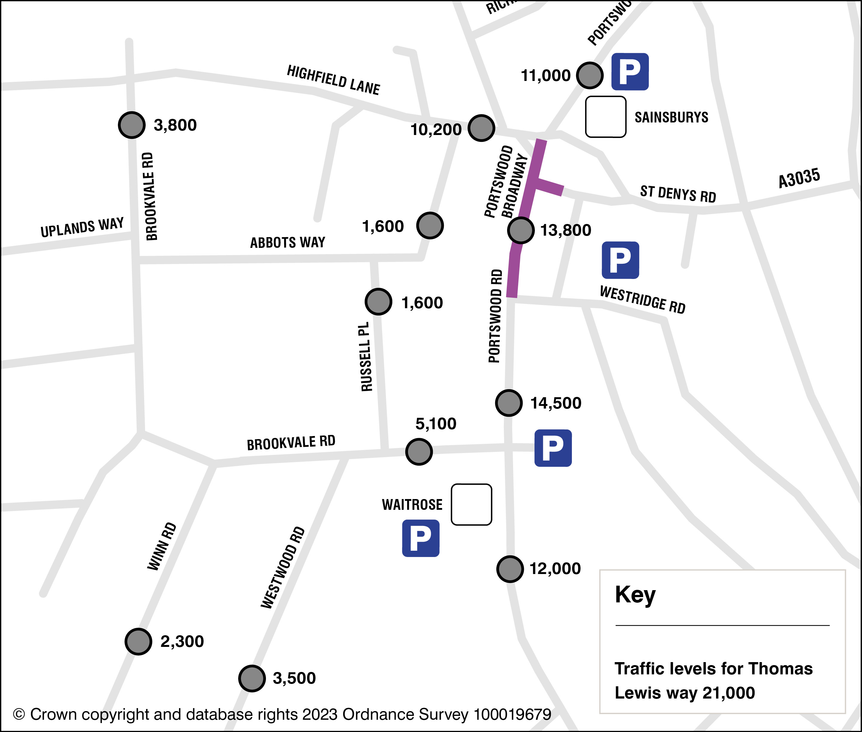
(click on image to expand)
Bus gate + no mitigation: This shows the impact on traffic flows along the Broadway and local roads should a bus gate be installed with no mitigation measures included, with the majority of traffic diverted to A335 Thomas Lewis Way. This is not something that would be implemented and is purely for demonstration purposes.
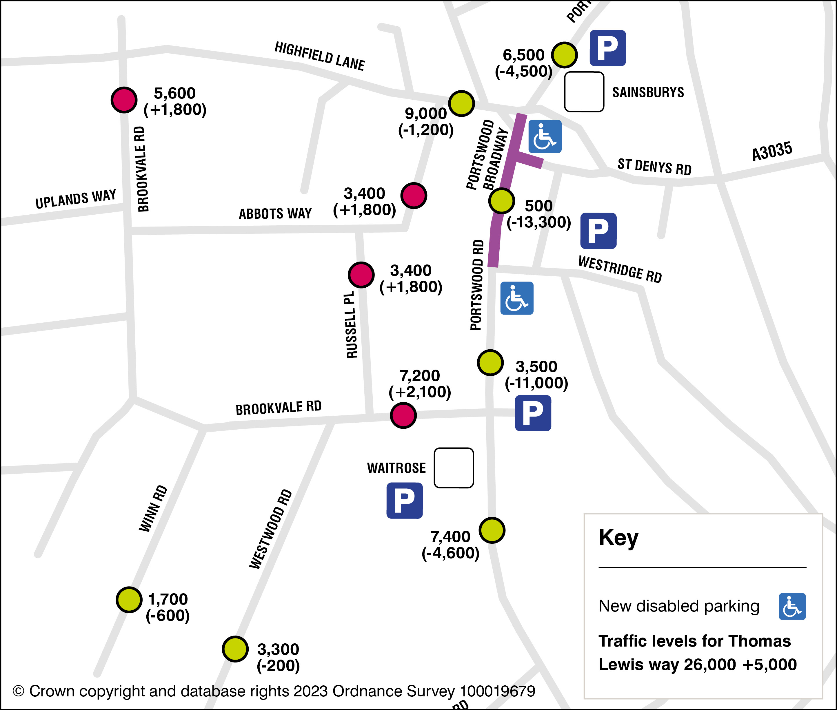
(click on image to expand)
Bus gate + Light-touch ATZ: This shows the impact on traffic flows should a bus gate be installed with a light touch ATZ.
A light-touch ATZ for Highfield would include new pedestrian crossings, speed cushions, priority buildouts to deter people from driving through residential streets, with the majority of traffic directed to A335 Thomas Lewis Way. This would help reduce overspill from the proposed bus gate and in most cases reduce traffic from existing levels.
This would lead to increased traffic levels on some local streets, but a significant reduction of traffic in the area as a whole. The final mix of interventions to deter people driving through residential streets would be based on community co-design.
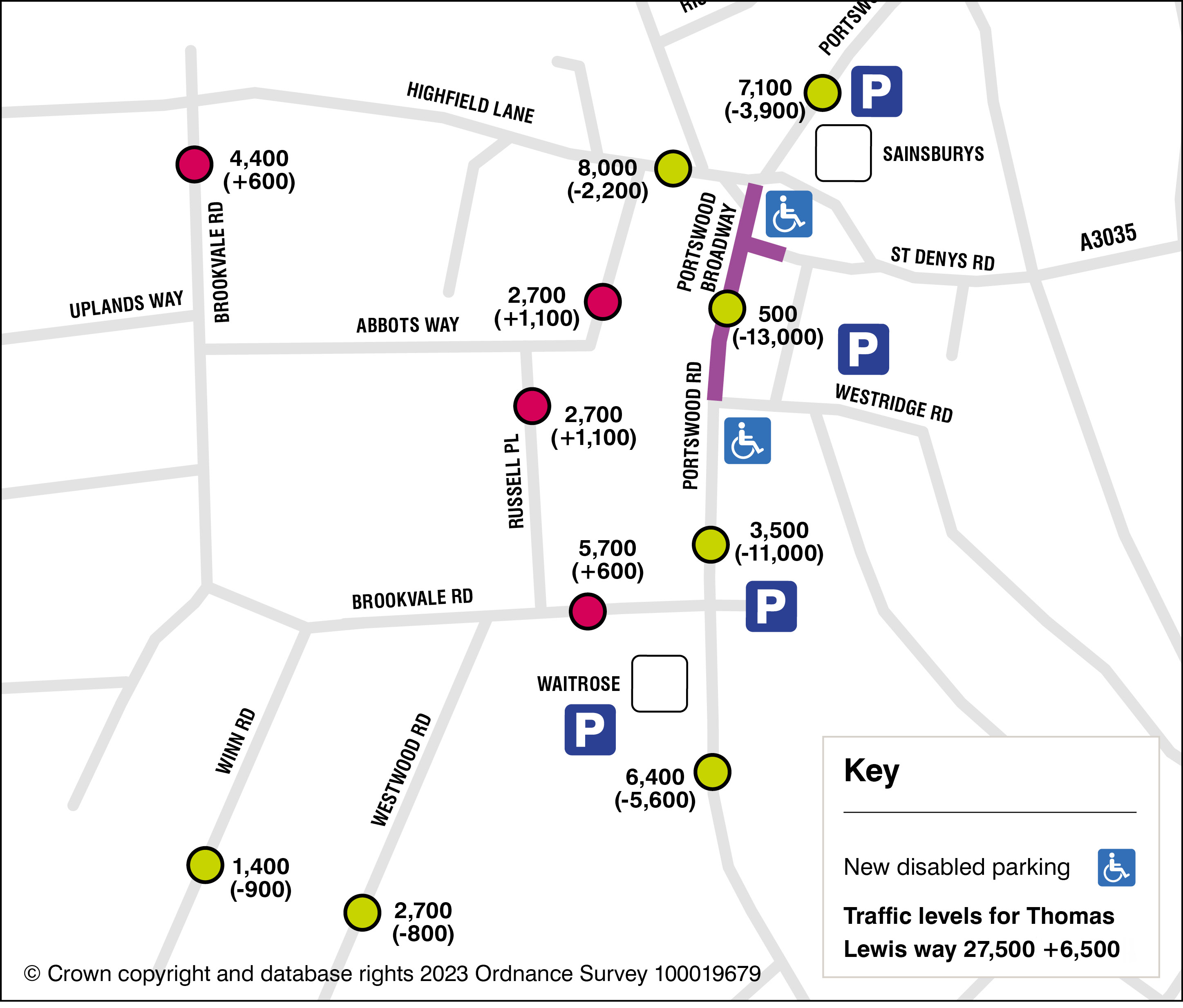
(click on image to expand)
Bus gate + ATZ with Traffic Filter on Russell Place and Brookvale Road: This shows the impact on traffic flows should a bus gate be installed with an ATZ, which would include a traffic filter on Russell Place and on Brookvale Road.
Traffic filters prevent motorised vehicles from passing through that area, without preventing people who walk and cycle. The predicted modelling shows that with the introduction of the ATZ and the traffic filters in these locations the roads around this area would be preserved for local residents and deliveries access only and prevent all through traffic.
Similar arrangements already exist in Outer Avenue (filters at Alma Avenue and at Avenue Road) and have just been introduced in St Denys (Kent Road, North Road and the existing filter at Horseshoe Bridge).
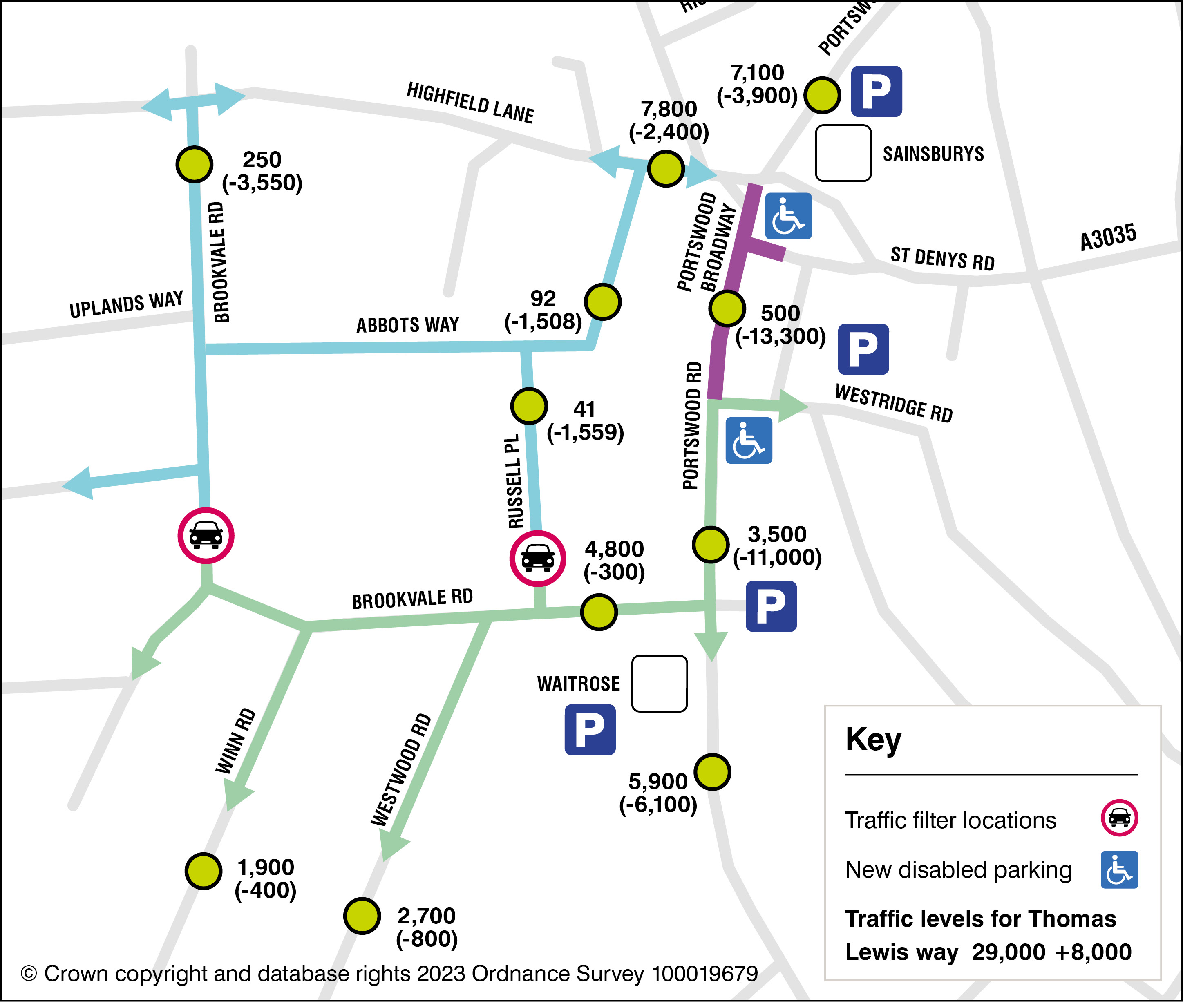
(click on image to expand)
We understand that by installing filters, local journeys will need to find a new way to travel to their destinations around the filters which may increase local journey times for local residents. This would however result in quieter residential roads which will make walking, wheeling and cycling more pleasant and safe.
Should an ATZ be implemented in the Highfield area, the council would further engage with the community to conduct co-design workshops in order to make sure that this scheme is designed to best protect and serve the community. No decision will be made on the style of Active Travel Zone (either light touch or with traffic filters) without community input into the process.
The workshops and implementation of the measures that are designed with the community would take place in Winter 2023 ahead of any works on Portswood Broadway.
Impact on Portswood Broadway
The result of this assessment can be seen in the figures above. The updated survey has shown around 13,000 vehicles passing through the Broadway each day, with approximately 70% travelling through without stopping. The introduction of a bus gate between Westridge Road and Highfield Lane would prevent this traffic from passing through the area, with up to 8,000 predicted to shift onto A335 Thomas Lewis Way. The remaining traffic would choose the Avenue or shift to easier modes of travel such as public transport.
Assessments show that A335 Thomas Lewis Way can take the additional traffic as a result of the improvements the council has implemented along this route to remove pinch points, improve signals and provide additional turning lanes.
For further information on this please see the section related to Thomas Lewis Way Improvements.
Please note: This assessment is a worst-case scenario and does not take into account any overall shift towards more sustainable options such as people choosing to walk or take a bus to replace a car trip, which is common to see with proposals such as this.
2. Impact on the local economy
One of the key concerns raised by residents during the consultation was about the economic impact on local businesses of a bus-only zone on a section of the Broadway. To address these concerns and measure the impact we commissioned an independent Economic Impact Assessment to look more specifically at the impact it would have on the Portswood area. You can see the full Economic Impact Assessment report via the link. This assessment has been based on and follows the principles set out in the HM Treasury Green Book. Key findings from the initial assessment include:
- The Portswood Broadway scheme will generate around £8 for every £1 of investment. The long-term economic benefits to the Southampton economy, through uplift in sales and increased employment opportunities, support the Southampton Pound* objective of community wealth building.
- An additional 30 full-time equivalent jobs. The proposals are predicted to generate additional jobs on the Broadway as the consumer benefits from increased trading space and longer opening hours to attract more people.
- An additional £32,705,000 (GVA) Gross Value Added over 10 years to the local economy. This is due to the increased footfall, compared with if the scheme was not implemented.
- A 5% uplift in trade. Businesses trading in retail, leisure, food services and other business services could expect a 5% uplift in trade from the additional footway space and improvements bringing more people to the area.
Introducing a bus gate and partial or full pedestrianisation of high streets is common practice to help rejuvenate and make places more competitive, sustainable and attractive. There are many examples across the country where proposals such as this one have gone forward and brought significant benefit to the community and the economy.
*Livings Streets, a sustainable transport charity, has worked to develop a report called the Pedestrian Pound which looks at the economic impact of schemes such as these across the UK. This report can be found here.
We hope the Economic Impact Assessment provides residents and businesses with some supporting information to help support inform their responses to the phase 2 consultation. We want to make sure that local businesses are fully supported as part of the second phase of consultation. We will therefore focus on providing advice and guidance on how businesses can get the full benefit of the scheme should it go ahead, and continue to work with them on the specific concerns raised.
Next Steps:
- Form Portswood Business Engagement Forum for local retailers
- Ensure servicing needs are designed into any future scheme
- Provide guidance on how to get the maximum benefit from these proposals.
If you are a local retailer and want to find out more about the Portswood Business Engagement Forum please email us at: portswoodcorridor@southampton.gov.uk
3. Maintaining access for people with mobility issues and people with disabilities
Access for people with mobility issues, especially those that have no alternative but to use their car will also be improved with better pedestrian access into Westridge Road Car Park and more parking for people with disabilities around the area.

(click on image to expand)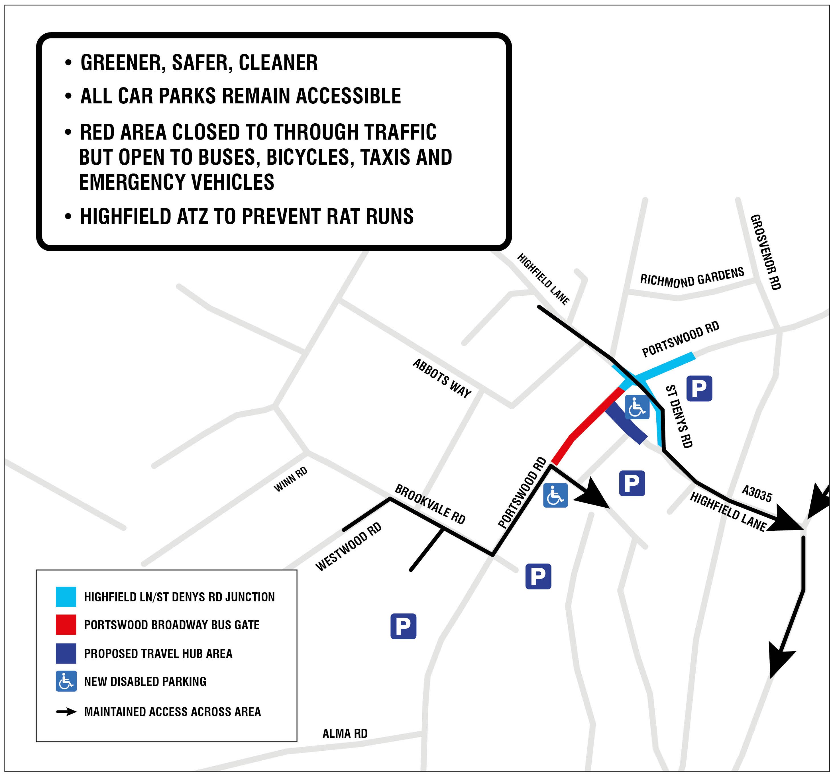
As part of the work on the Active Travel Zone we would also include additional disabled compliant crossings and improve the condition of our footways.
There will be at around seven additional benches along the Broadway for people to sit and rest, and hospitality businesses will be able to offer outdoor seating, where people can socialise with family and friends. The area will be improved with dementia friendly design principles being applied to the design of the future Broadway layout. Our new Accessibility Forum will play a crucial role in reviewing the scheme and the design detail.
While some people may need to make longer journeys around the bus gate, we commit to maintaining access to all car parks in the area and improving existing access.
4. Phased Implementation of the scheme
We are currently investigating the phased introduction of the bus gate should the proposals move forward. We would also be able to provide temporary additional paving along the Broadway to provide the extra pedestrian space the bus gate would allow us to install. It is important to know that during a phased approach of this scheme we would not be able to provide any of the additional green space initially and it would be added over a longer time frame.
If the consultation indicates support for a phased implementation, the council will investigate carrying out the scheme in phases with the Active Travel Zone and the Bus Gate to be installed before significant works are carried out on Portswood Broadway. This would allow more time for the community to feed into the design process for the Broadway improvements and to trial the bus gate and its effects enabling us to take any additional mitigation measures should they be needed.
5. Air quality and environmental benefits
Southampton City Council adopted its Green City Charter in 2020, establishing a vision and a set of commitments that seek to achieve improvements in the city’s environment. This includes actions to improve air quality, the natural environment and achieve a 2030 net zero target for emissions from its own operations and services.
With nearly a third of the city’ carbon emissions coming from the transport section, reducing motor vehicle emissions and providing reliable and safe alternative modes of travel is a key part of metting our targets and improving our air. Without a significant mode shift away from driving, it is unlikely that Southampton will achieve Net Zero by 2035.
Improved opportunities for active travel and providing a more reliable bus corridor along Portswood Road will bring environmental value by helping to improve air quality and the overall health and wellbeing of participants.
To improve the poor air quality in this area, the scheme aims to prevent through traffic from further reducing the air quality unnecessarily. It will also make it easier to use less polluting modes of travel such as taking a bus or walking and cycling.
For details of the City’s Net Zero Strategy please visit our website: Southampton Net Zero Strategy. For more information on air quality monitoring please visit our website: Monitoring and reporting. More information on what the council are doing about poor air quality can be found at: What are we doing to improve air quality?
6. Improving public transport services
Providing a more reliable and faster bus service along Portswood Road from Eastleigh to Southampton City Centre is one of the main objectives of the Transforming Cities Fund (TCF) programme. As part of these proposals we can address the delays to buses caused along Portswood Road by congestion and the onwards delays this has on people's journeys by bus.
The Southampton Bus Service Improvement Plan (BSIP) has a target to make 95% of bus services in Southampton on time (described as within 5 minutes late and 1 minute early). This corridor is an important strategic route for the city linking to major employers such as the airport, our universities and Portswood district centre with nearly 500 buses a day travelling through it. Unfortunately, congestion is causing significant delays to buses in this area with the BlueStar 2 and 20 services suffering from only being on time an average of 73% and 64%, well below our target of 95%.
These proposals along with other improvements along the route from the City Centre to Eastleigh could improve journey times by up to 10 minutes along the corridor. By reducing these delays we can provide residents, workers and visitors with a more reliable bus network and a low carbon alternative to traveling through the area. You can read more about our Bus Service Improvement Plan here Bus Service Improvement Plan.
7. Tackling crime and antisocial behaviour
Crime and antisocial behaviour was a key concern raised in phase 1 of the consultation and one we share. Local street drinking, assaults, theft and other crimes are something we all take very seriously.
The Council, in partnership with our local police officers, are working to ensure these proposals would help address these problems and make the Portswood area safer for us all to enjoy. These proposals would allow us to:
- Provide additional CCTV along the Broadway, helping the police to gather evidence and monitor crimes;
- Design out blind spots and improve street lighting;
- Work with local businesses to form the Portswood Business Engagement Forum which will help the council and the police to work better together with local businesses;
- Working on community schemes that allow people to better and more easily report crimes.
We are trialling an e-scooter hiring system across the city and many people have raised concerns about people riding on the footway or other unsociable use. Should you see an incident you can report it at Voi Scooters - Report a Voi and it will be investigated. The Council has been working with Voi to undertake on site enforcement in the Portswood Broadway area to issue warnings / riding bans for pavement riding.
8. A335 Thomas Lewis Way Improvements
The improvements to A335 Thomas Lewis Way (TLW) aim to enhance the strategic function of the corridor in the movement of through traffic in and out of the city and so reduce the demand and need for through traffic using Portswood Broadway. A full assessment of the impact of these improvements is now being conducted and early indications show that some journey times have improved by up to 12.4% along the whole corridor.
These proposals would mean that up to 8,000 vehicles would shift away from Portswood Broadway and onto Thomas Lewis Way. These would make use of the additional capacity provided along this corridor.
Improvements to TLW were conducted at key junctions with signal technology being upgraded, pinch points being removed and crossing facilities being upgraded at its junction with St Denys Road. The value of these works is in the order of £1.5m, with Mayfield junction and signal upgrades at St Denys Road junction and Horseshoe Bridge junction now complete.
Our traffic modelling on proposed scenarios to assess the impact of the scheme, combined with our current monitoring of journey times along the corridor following the recent upgrades, means that A335 Thomas Lewis Way is able to cope with the additional traffic that will be rerouted from Portswood Broadway.
9. Emergency Strategy for A335 Thomas Lewis Way
It will be important with the proposals for Portswood Broadway to maintain an alternative route should A335 Thomas Lewis way become blocked or inaccessible. To address concerns raised during the Phase 1 consultation Southampton City Council has put together an emergency strategy for Thomas Lewis Way. This outlines various scenarios in which traffic can be diverted around A335 Thomas Lewis Way should be become inaccessible.
In this unlikely situation, advanced warning signs will give drivers advance notice of the closure and the need to divert to alternative A road routes, with local traffic using Portswood Broadway should the bus gate need suspending. The full emergency Strategy Report can be found here.
The council is also pursuing additional monitoring along the road to identify and resolve any ongoing issues such as flooding. An investigation has commenced into addressing the flooding issue and improving the capacity of the drainage network on A335 TLW.