Summary
- Where: Freemantle C of E Academy area
- When: Initial perceptions survey July 2023
- What: Safer routes to school
- Why: To improve the local environment for residents, walking and cycling for local journeys.
- How: Funding from the Government's Active Travel Fund.
Latest Updates
August 2024-COMPLETE!
The works carried out on Waterloo Road have finished, thank you to the residents and motor users for their understanding while the construction phases were underway! Please read below what developments have been enabled by the Governments Active Travel Fund:
- Zebra crossing for improved visibility of public
- Footpath widening for traffic calming and safety
- Highway maintenance repairs
July 2024
Following the below feedback, we will now be constructing a zebra crossing on Waterloo Road as well as making minor changes to the junction with Varna Road.
Improvements will include:
- Construction of a new zebra crossing west of Varna Road, improving accessibility for local residents, including children accessing Freemantle C of E Academy.
- Footway widening to facilitate this zebra crossing, as well as aiding with traffic calming.
We will also take the opportunity coordinate additional highway maintenance activities along Waterloo Road whilst we make these improvements.
This work is planned to take place from Monday 29th July 2024, and the construction of the zebra crossing will take approximately 4 weeks. We will also revisit the area approximately 2 weeks after construction in order to lay the anti-skid surfacing, however this will be communicated by letter closer to the time.
During construction, a road closure on Waterloo Road will be in place for 4 weeks, between numbers 110a and 91. There will also be a junction closure on Varna Road, to allow us to work on the footways at the junction, however the no-entry to Varna Road from Millbrook Road East will temporarily be lifted to maintain residents’ access.
Carriageway repairs on Waterloo Road
During this 4-week closure, we will also undertake repairs on other sections of Waterloo Road. This is expected to take place over 2 days, beginning on Thursday 15th August. On the first day of repairs, the closure will extend to the junction with Park Road whilst we make repairs to the road surface between the junctions with Varna Road and Park Road.
On Friday 16th August, we will then be working on the section of Waterloo Road between the Park Road junction and Shirley Road, with a closure in place in this area. We will reopen the closure in place for the zebra crossing to accommodate resident access from Paynes Road, however temporary lights will be in place to guide traffic around the works area.
The works will then return to the original closure extent from Monday 19th August, with the closure on Waterloo Road between numbers 110a and 91.
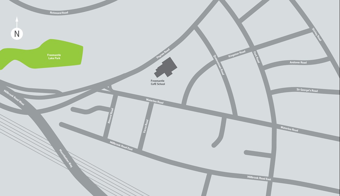
Map of the works area during the zebra crossing installation and repairs on 15th August:

Map of the repairs taking place on 16th August:

Pedestrian access will be maintained throughout, however nearby parking may be suspended, and parking will not be possible within the closure extent. Residents are advised to find alternative parking, however, please speak to the team once they arrive on site if you have any concerns regarding this or any changes to your access needs or are expecting any large deliveries.
The bus stops on Waterloo Road will be suspended during construction, and the bus operators will design and manage their own diversion routes or temporary stops, so please reach out to your bus operator if you are planning to travel, and plan your journeys in advance where you can. Access for emergency vehicles will always be maintained. We would also like to assure you that we will facilitate refuse collection during this time.
If you have any concerns or questions, please reach out to our team on roadworks@southampton.gov.uk.
October 2023
In July of this year, we asked for your views on Road Safety, in particular walking and cycling to Freemantle C of E School. We have now considered what measures could be introduced to address the concerns you raised (see summary of survey results below).
We would now like to hear your views, to help inform what measures may progress to construction later this year. You can view the proposed measures and comment on them here.
Currently, these are only proposed measures and are subject to change based on the feedback we receive during the consultation.
Summary of Survey Results
Adults – including Local Residents, Parents of children at Freemantle C of E School,
The main modes of travel within the area are motor vehicle or walking, and over half of respondents choose their main mode of travel because it is convenient.
The most frequently selected barriers to cycling in the area are: the road/infrastructure is not safe (47%); bad road user behaviour (44%).
The most frequently selected barrier to walking in the area is the time or distance of the journey (36%).
Respondents told us they were most satisfied with the access to local amenities and connections to public transport.
Respondents told us they are most dissatisfied with the conditions of pavements and the quality of air.
92% of respondents support improvements to road safety and 49% told us that improvements to walking and cycling would encourage them to walk or cycle more.
There were 15 separate suggestions made within the survey for less traffic and more traffic calming measures.
Pupils of Freemantle C of E School
76% said they would like to see fewer cars on the street when they go to and from school.
83% said they would like to have more places to safely cross the road.
79% said they would like to have more space to walk, cycle, scoot and wheel to school.
Proposed Measures
A new zebra crossing on Waterloo Road, just west of Varna Road, to promote walking on a busy desire line.
Project Details
This project will create an improved environment for walking and cycling in this area for local trips as well as joining wider Cycle network. This may include traffic calming to reduce the number of vehicles and ensure lower vehicle speeds. Measures will be informed through local consultation
In July, we contacted residents and pupils to ask their opinions on walking and cycling routes in this area through an online survey.
The survey is now closed.
Please see the report analysis with the results from the survey.
We will update residents when the next round of engagement is open.
Map of area
