Scheme background: What is an Active Travel Zone?
Active Travel Zones are neighbourhoods that encourage active travel through a range of measures which calm or discourage traffic and instead prioritise people walking and cycling. Measures may include:
- Strategic road closures using modal filters, such as bollards or planters, to prevent rat running while retaining access for pedestrians and cyclists.
- Two-way in/one-way out where cars can enter and exit at one end of the road but only exit at the other, to help reduce rat-running.
- Echelon parking to save space and encourage slower traffic speeds.
- Contraflow cycling where cyclists are allowed to ride in both directions on a street that is one-way for cars, making cycling more convenient and offering safer alternatives to busy roads.
- Continuous footways where pedestrians and cyclists have priority over vehicles at junctions.
Scheme background: Why does Southampton need Active Travel Zones?
Streets in many residential neighbourhoods in Southampton are treated as short cuts by drivers avoiding main roads and often travelling at speed. In some streets, traffic data and residents report speed and volumes at unacceptably dangerous levels, making active travel intimidating; streets noisy; and socialising difficult for local neighbours and children.
The council is committed to improving road safety across the city and Active Travel Zones can support this by creating a safer, more attractive environment where people can walk and cycle with greater ease for shorter local journeys. Enabling more sustainable travel patterns in this way can also help to boost the council's wider aims to tackle pollution, reduce congestion and improve public health.
Scheme background: How was Woolston chosen?
We worked with a data specialist to identify residential areas across the city that would benefit from an Active Travel Zone. This process looked at the layout of the streets and local amenities and whether the measures which could be added as part of an Active Travel Zone would help more residents walk and cycle. The process also looked at the likely benefit that an Active Travel Zone could have on congestion, safety, health and wellbeing.
Scheme background: How is this project being funded?
The funding for this project comes from the Department for Transport’s Transforming Cities Fund. As this is grant funding, it is ringfenced specifically for the delivery of an Active Travel Zone and can’t be used for other transport schemes or other council services.
SEA ROAD: How long will these works take?
The improvements on Sea Road will take approximately 4 weeks, beginning Monday 6th November 2023. During this time, Sea Road will be closed between Hazel Road and Hill Street.
The working hours for our operatives will be between 7:00am - 5:30pm, Monday to Friday, and 7:00am to 1:00pm on Saturdays; however, the closure will be in place for the duration of the works due to the excavation required.
SEA ROAD: What will resident access to Hill Street look like during the works?
Our closure extends to the entrance of Hill Street but will not cover it, so resident access will be maintained via the east rather than Hazel Road.
There will be an occasion where our resurfacing extent will cover the entrance to Hill Street, however residents will be informed of this closer to the time.
SEA ROAD: What are the works implementing?
This will create a safer environment for pedestrians and cyclists along Sea Road with the implementation of footway improvements and a traffic filter. We will also make improvements to existing footways and other infrastructure on Sea Road.
BRIDGE ROAD: What works are being done?
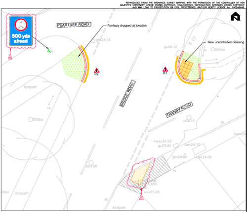
The works on Bridge Road include minor repairs and refreshments to tactile crossings in the region, as well as kerbing works as can be seen in the drawing below.

The design drawing of the improvement works at Bridge Road, shows, in green, dropped footways at the junction of Peartree Road and Bridge Road (south side) and at the junction of Bridge Road and Tranby Road (north side), new kerb lines, in red, and new double yellow lines, in yellow, as well as new tactile paving, represented by yellow squares, and new signage.
BRIDGE ROAD: What proposals did not go ahead?
Following investigations the potential for a zebra crossing on Bridge Road was proven to not be feasible as part of the ATZ project and therefore is not a part of the current works. We have taken a detailed look at possible alternative locations up to the Sholing Road roundabout, and at installing a different type of crossing, however this highlighted issues which make a new crossing along this part of Bridge Road not viable at this time.
BRIDGE ROAD: What will the traffic management look like for vehicles/buses?
The works will take approximately 1 week and will commence from the end of the Sea Road improvements.
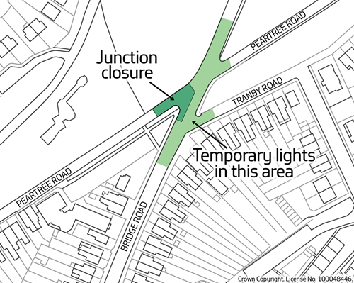
During the week, there will be temporary traffic signals on Bridge Road between the junctions of Peartree Road and Tranby Road. There will also be a junction closure of Peartree Road/Bridge Road (west) in order to prevent vehicles turning into the works area, which will be directly adjacent to the junction.

Bus routes on Bridge Road will be unaffected, however it is always best to check directly with the bus provider before travelling in case of any changes: https://www.bluestarbus.co.uk/service-updates
BRIDGE ROAD: How do I get to my house on Sea Road/Defender Road/Hill Street (etc.)?
Access to properties on Sea Road and Hill Street will be maintained via Defender Road, which will remain open throughout. Tankerville Road and Shamrock Road will also be unaffected, however there may be some delays whilst the temporary traffic signals are in operation, so please plan your journeys ahead.
BISHOPS ROAD: When will these works commence?
Residents will be informed closer to the time in writing, however these works are currently planned to take place in January 2024.