West of Warren Crescent (Zone 7 extension) locality
Public Notice
THE CITY OF SOUTHAMPTON (STATIC RESTRICTIONS) (WEST) ORDER 2019
NOTICE IS HEREBY GIVEN THAT SOUTHAMPTON CITY COUNCIL proposes to make the above Order, the effects of which in this locality are shown in the plan below. Copies of the draft Order, relevant plans and statement of reasons for proposing may be inspected during normal working hours at Civic Centre, Southampton, SO14 7LY. Further information may be obtained from Southampton Highways by emailing southamptonRPS@balfourbeatty.com or by phone on 023 8079 8027. Any person wishing to object to the Order must write to the Highways Legal Team at Southampton City Council, Civic Centre, Southampton, SO14 7LY or email Traffic.Orders.Legal@southampton.gov.uk quoting the Order Title you are objecting to and stating the grounds for objection, within 21 days of the date of this Notice (i.e. by 5th July 2019).
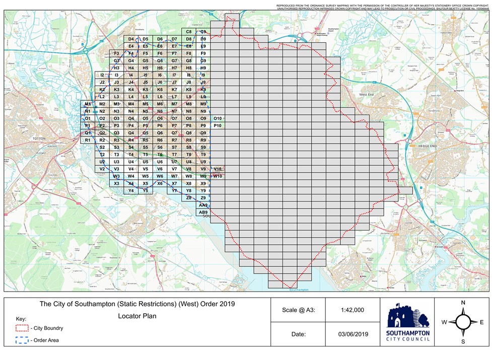
This plan can be viewed in a larger format.
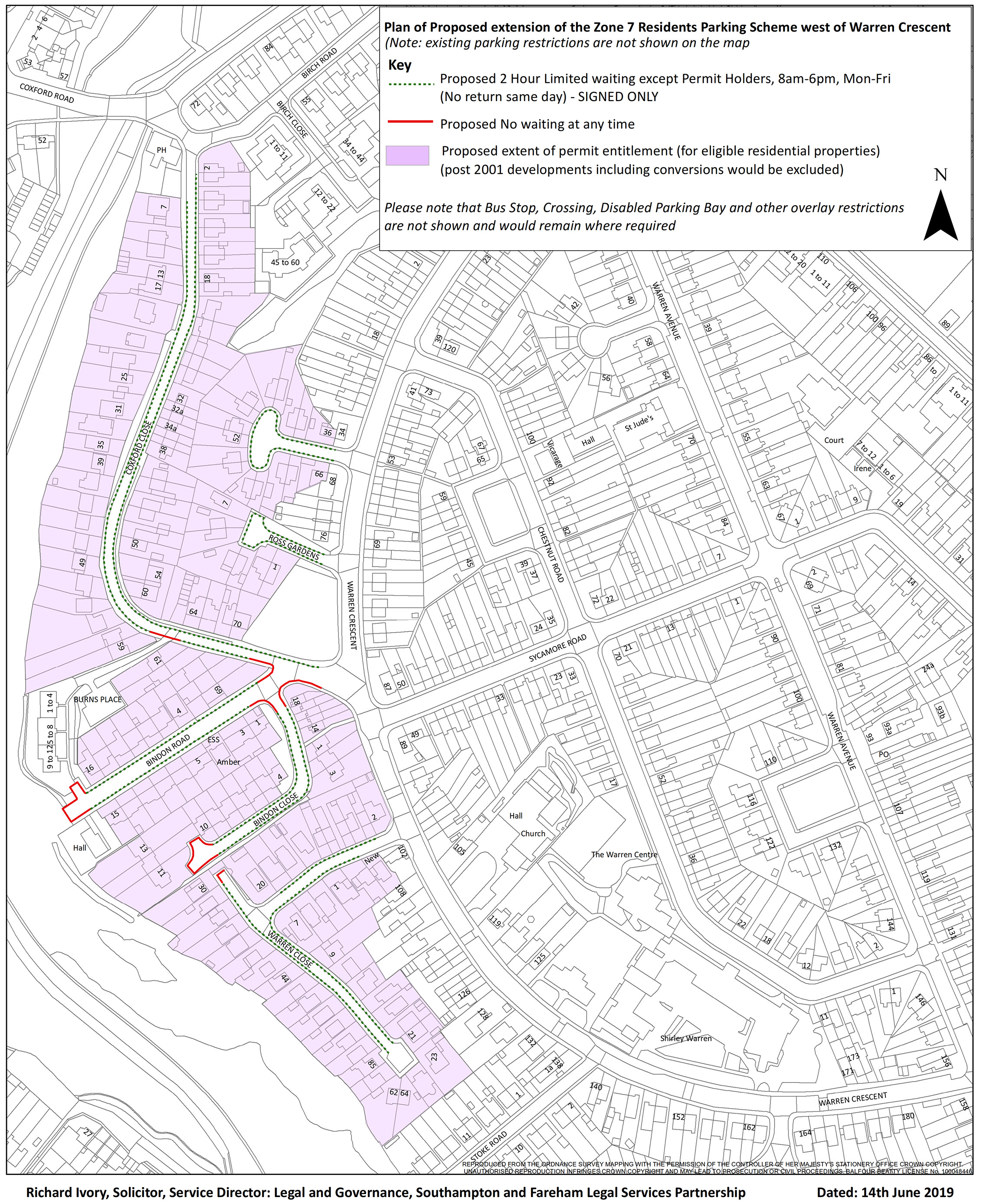
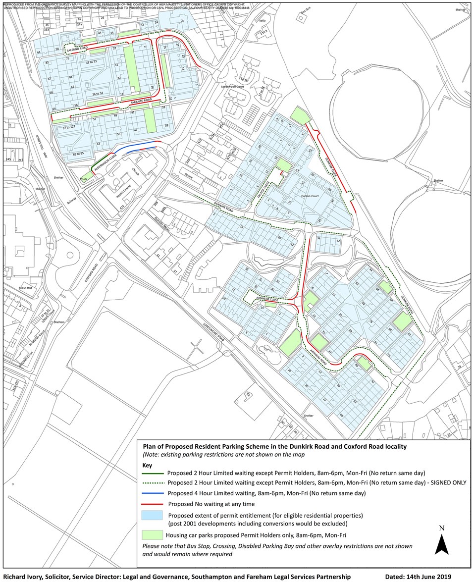
Dunkirk Road/Coxford Road locality
Public Notice
THE CITY OF SOUTHAMPTON (STATIC RESTRICTIONS) (WEST) ORDER 2019
NOTICE IS HEREBY GIVEN THAT SOUTHAMPTON CITY COUNCIL proposes to make the above Order, the effects of which in this locality are shown in the plan below. Copies of the draft Order, relevant plans and statement of reasons for proposing may be inspected during normal working hours at Civic Centre, Southampton, SO14 7LY. Further information may be obtained from Southampton Highways by emailing southamptonRPS@balfourbeatty.com or by phone on 023 8079 8027. Any person wishing to object to the Order must write to the Highways Legal Team at Southampton City Council, Civic Centre, Southampton, SO14 7LY or email Traffic.Orders.Legal@southampton.gov.uk quoting the Order Title you are objecting to and stating the grounds for objection, within 21 days of the date of this Notice (i.e. by 5th July 2019).
This plan can be viewed in a larger format.
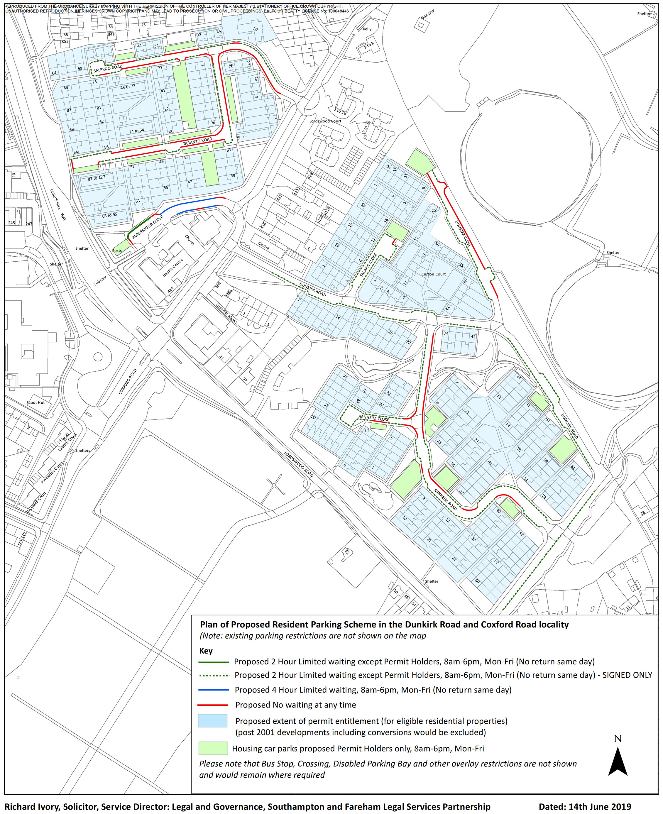
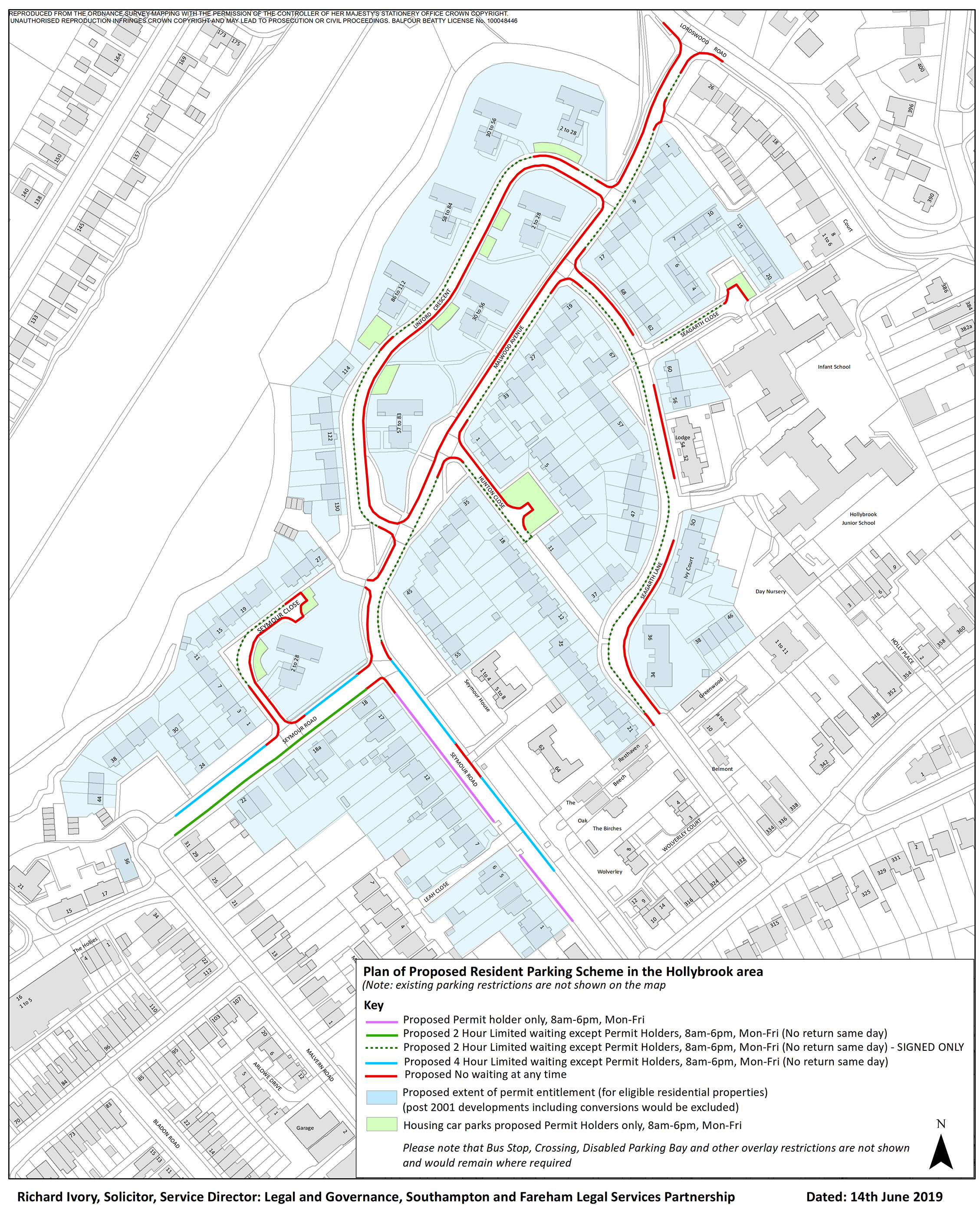
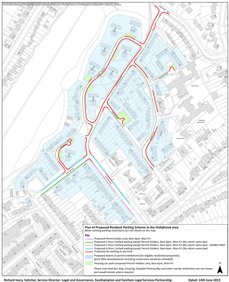
Hollybrook locality
Public Notice
THE CITY OF SOUTHAMPTON (STATIC RESTRICTIONS) (WEST) ORDER 2019
NOTICE IS HEREBY GIVEN THAT SOUTHAMPTON CITY COUNCIL proposes to make the above Order, the effects of which in this locality are shown in the plan below. Copies of the draft Order, relevant plans and statement of reasons for proposing may be inspected during normal working hours at Civic Centre, Southampton, SO14 7LY. Further information may be obtained from Southampton Highways by emailing southamptonRPS@balfourbeatty.com or by phone on 023 8079 8027. Any person wishing to object to the Order must write to the Highways Legal Team at Southampton City Council, Civic Centre, Southampton, SO14 7LY or email Traffic.Orders.Legal@southampton.gov.uk quoting the Order Title you are objecting to and stating the grounds for objection, within 21 days of the date of this Notice (i.e. by 5th July 2019).
This plan can be viewed in a larger format.
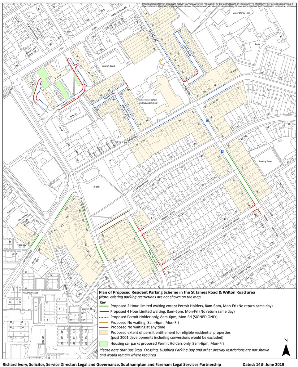
St James Park & Wilton Road locality
Public Notice
THE CITY OF SOUTHAMPTON (STATIC RESTRICTIONS) (WEST) ORDER 2019
NOTICE IS HEREBY GIVEN THAT SOUTHAMPTON CITY COUNCIL proposes to make the above Order, the effects of which in this locality are shown in the plan below. Copies of the draft Order, relevant plans and statement of reasons for proposing may be inspected during normal working hours at Civic Centre, Southampton, SO14 7LY. Further information may be obtained from Southampton Highways by emailing southamptonRPS@balfourbeatty.com or by phone on 023 8079 8027. Any person wishing to object to the Order must write to the Highways Legal Team at Southampton City Council, Civic Centre, Southampton, SO14 7LY or email Traffic.Orders.Legal@southampton.gov.uk quoting the Order Title you are objecting to and stating the grounds for objection, within 21 days of the date of this Notice (i.e. by 5th July 2019).
This plan can be viewed in a larger format.
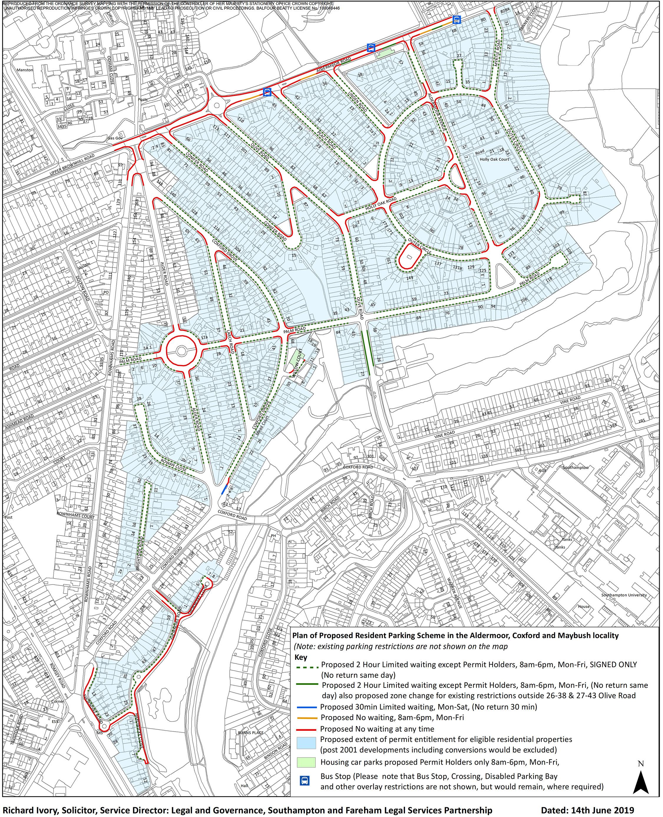
Maybush, Coxford & Aldermoor locality
Public Notice
THE CITY OF SOUTHAMPTON (STATIC RESTRICTIONS) (WEST) ORDER 2019
NOTICE IS HEREBY GIVEN THAT SOUTHAMPTON CITY COUNCIL proposes to make the above Order, the effects of which in this locality are shown in the plan below. Copies of the draft Order, relevant plans and statement of reasons for proposing may be inspected during normal working hours at Civic Centre, Southampton, SO14 7LY. Further information may be obtained from Southampton Highways by emailing southamptonRPS@balfourbeatty.com or by phone on 023 8079 8027. Any person wishing to object to the Order must write to the Highways Legal Team at Southampton City Council, Civic Centre, Southampton, SO14 7LY or email Traffic.Orders.Legal@southampton.gov.uk quoting the Order Title you are objecting to and stating the grounds for objection, within 21 days of the date of this Notice (i.e. by 5th July 2019).
This plan can be viewed in a larger format.
Statement of Reasons
THE CITY OF SOUTHAMPTON (STATIC RESTRICTIONS) (WEST) ORDER 2019
Statement of Reasons
This Order is being proposed for the following reasons:
1: Southampton General Hospital is a major employer in the western part of the city, which employs over 11,500 staff, many of whom travel to the site from across a wide area. As the hospital has grown into a major regional hospital, providing a broader range of health services for patients, it no longer has sufficient on-site car parking to meet the level of demand from staff – as on-site parking is prioritised for the needs of the 750,000 patients a year that use the site.
Although Park and Ride facilities are available for staff in the form of the 1,000 space site at Adanac Park, which the Hospital are now strongly promoting and encouraging staff to use, not all those eligible choose to use it, and not all shift work staff are permitted to or willing to pay for the cost of on-site staff parking at the hospital. This means some staff are choosing instead to park in nearby residential neighbourhoods and walk a short distance to work.
The existing Residents Parking Zone 7 (operating 8am until 6pm Mondays to Fridays & in most streets allowing a maximum of 2 hours limited waiting) covers several residential roads around the hospital site and has been extended a number of times to cover additional roads where residents have requested the introduction of a permit scheme to address problems caused by hospital staff commuter parking. This has partly addressed the problem of staff parking close to the site.
However, the Council is aware from feedback received from residents (both at the Drop In Engagement event held on 21st November 2017 at the Hospital and subsequently received) that there are a large number of roads beyond the existing Zone 7 where all day parking by hospital workers is taking place which is causing difficulties and issues for residents.
A survey of residents was undertaken in November and December 2018 to establish the level of support for permit parking measures. The proposals have been developed based on this feedback and based on subsequent discussions and feedback from ward councillors.
2: For avoiding danger to persons or other traffic using the road or any other road for preventing the likelihood of any such danger rising.
3: For facilitating the passage on the road or any other road of any class of traffic.
4: For preserving or improving the amenities of the area through which the road runs.
5: In authorising the advertisement of these proposals the Council has given consideration to its duty under s.122 of the Road Traffic Regulation Act 1984 to secure the expeditious, convenient and safe movement of vehicular and other traffic (including pedestrians) and the provision of suitable and adequate parking facilities on and off the highway (while having regard to the matters specified in s.122 subsection (2) of that Act).
Press notice
THE CITY OF SOUTHAMPTON (STATIC RESTRICTIONS) (WEST) ORDER 2019
NOTICE IS HEREBY GIVEN THAT SOUTHAMPTON CITY COUNCIL proposes to make the above Order, the effects of which would be:
1. To introduce No waiting at any time restrictions in the following lengths of roads:
Alder Road: both sides, from its northernmost junction with Palm Road northwards for 10m; east side, from Palm Road (southernmost junction) southwards to the northern boundary of 36 Alder Road; north-east side, from the north-western boundary of 86A Alder Road north-westwards to its junction with Coxford Drove; west side, from its junction with Rownhams Road south-eastwards for 21m and from Palm Road (southernmost junction) southwards to the northern boundary of 37 Alder Road.
Aldermoor Avenue: both sides, from Outer Circle (northernmost junction) north-westwards for 20m, from Outer Circle (southernmost junction) northwards for 10m; north-east side, from Outer Circle (northernmost junction) south-eastwards for 15m and from Aldermoor Road south-eastwards for 20m and south-west side, from Aldermoor Road south-eastwards for 15m, from Outer Circle (northernmost junction) south-eastwards for 11m and from the boundary of 18/20 Aldermoor Avenue north-westwards for 123m.
Aldermoor Close: north side, from 10.5m west of Coxford Road westwards for 8m; north-west side, from 27m north of the closed end north-eastwards for 10m; south side, from 13m west of Coxford Road westwards for 2m and from 26m west of Coxford Close westwards for 8m and south-west side, from the southern end of the car park access north-westwards for 6m.
Aldermoor Road: north-west side, from its junction with Upper Brownhill Road north-eastwards to 10m west of Lewis Silkin Way; south-east side, from 15m south-west of Aldermoor Avenue north-eastwards to the north-eastern boundary of 54 Aldermoor Road, from the north-eastern boundary of 34 Aldermoor Road north-eastwards for 39m, from the north-eastern boundary of 34 Aldermoor Road north-eastwards for 39m, from the south-western boundary of 24 Aldermoor Road to the north-eastern boundary of 26 Aldermoor Road, from Rownhams Road north-eastwards to the south-western boundary of 16 Aldermoor Road and from 13.5m south-west of the south-western boundary of 40 Aldermoor Road north-eastwards to the south-western boundary of 50 Aldermoor Road.
Arnheim Close: both sides, from Arnheim Road westwards for 10m; south-side, from 25m west of Arnheim Road westwards for 14m.
Arnheim Road: east side, from 10m south of Arnheim Close northwards to 10m south of Dunkirk Road (northernmost junction); north side, from the end of the lay-by at the rear of 37 Arnheim Road westwards for 15m; north-east side, from the southern end of the lay-by outside 23 & 35 Arnheim Road south-eastwards for 26m, west side, from the northern end of the lay-by at the rear of 1 Arnheim Close northwards to 10m north of Arnheim Close, and from 27m south of the northern end of the lay-by at the rear of 1 Arnheim Close southwards for 7m and south-west and south-east side, from 5m north-east of the north-eastern boundary of 40 Arnheim Road north-east and then south-eastwards for 24m.
Bindon Close: both sides, from Bindon Road south-eastwards for 10m; closed-end, for its entire length; north-west side, from the closed end north-eastwards to 5m south-west of the boundary of 9/10 Bindon Close (including the turning head) and south-east side, from the south-western closed end north-eastwards for 16m.
Bindon Road: closed end, for its entire length; north-west side, from the closed end north-eastwards to the extent of the north-western turning head (including the turning head), from Coxford Close south-westwards for 14m and south-east side, from its closed end north-eastwards for 12m and south-east side: from 10m south-west of Bindon Close north-eastwards to Coxford Close.
Bourne Avenue: both sides, from Twyford Avenue north-eastwards for 10m.
Branksome Avenue: both sides, from Twyford Avenue north-eastwards for 10m and from Wilton Road south-westwards for 10m.
Chelveston Crescent: both sides, from Aldermoor Road northwards for 20m.
Conifer Road: both sides, from Aldermoor Road south-eastwards to the north-eastern boundary of 81 Conifer Road; north-east side, from its junction with Olive Road south-eastwards to the north-western boundary of 1 Conifer Road; north-east & south-west side, from the south-eastern boundary of 14 Conifer Road south-eastwards and then north-westwards for 29m and south-west side, from its junction with Olive Road south-eastwards for 8m.
Coxford Close: south-west side, from the boundary of 67/69 Coxford Close south-eastwards to 15m north-west of Warren Crescent and across the accesses to 59 and 61 Coxford Close, including the access to Burns Place.
Coxford Drove: both sides, from 10m north to 10m south of Palm Road; south-east side, from 4m south-west of the south-western boundary of 8 Coxford Drive north-eastwards for 11m; south-west side, from its junction with Alder Road south-eastwards for 14m and from the north-western boundary of 46 Larch Road north-westwards to the boundary of 61/63 Coxford Drove.
Dunkirk Close: north-east side, from the southern end of the lay-by opposite 45 & 50 Curzon Court south-eastwards for 16m and from 11m south-east of the end of Dunkirk Close south- eastwards to the northern end of the lay-by opposite 45 & 50 Curzon Court; south-west side, from the end of Dunkirk Close south-eastwards for 23m.
Falaise Close: south-east side, from the car park entrance south-westwards for 5m
Hardwicke Close: closed end, for its entire length; east side, for its entire length; south-west side, from the northern boundary of 1 Hardwicke Close north-westwards to its junction with Thorndike Road and west side, from its closed end northwards to the boundary of 8/9 Hardwicke Close.
Holly Oak Road: both sides, from Olive Road north-eastwards for 10m, from Outer Circle south-westwards for 10m, from Outer Circle eastwards for 12m, from Aldermoor Avenue (northernmost junction) south-westwards for 10m and from Aldermoor Avenue (southernmost junction) westwards for 10m; north-west side; from the north-eastern boundary of 23 Holly Oak Road south-westwards for 15m; south-east and south-west side, from the south-western boundary of 22 Holly Oak Road north-eastwards eastwards for 20m.
Hunton Close: north-east side, from Malwood Avenue south-eastwards around the access to the off-road parking to 5m north-west of its closed end and south-west side, from Malwood Avenue south-eastwards for 10m.
Larch Road: both sides, from 10m north to 10m south of Palm Road; east side, from the northern boundary of 46 Larch Road northwards to its junction with Coxford Drove and south-west side, from the boundary of 71/73 Larch Road northwards to its junction with Coxford Drove.
Linden Road: both sides, from Aldermoor Road south-eastwards for 14m and from Outer Circle north-westwards for 10m.
Linford Crescent: inner side, for its entire length; outer north side, across the off-road parking area in front of 2 to 28 Malwood Avenue; outer north-east side, from Malwood Avenue (northernmost junction) north-westwards for 10m; outer north-west side, across the access to the car parking area on the south-west side of 86 to 112 Malwood Avenue and outer south- west side, from Malwood Avenue (southernmost junction) north-westwards for 10m.
Lordswood Road: south-west side, from 15m north-west to 15m south-east of Malwood Avenue.
Malwood Avenue: north-east side, from its junction with Seymour Road north-westwards for 10m; north-west side, for its entire length and south-east side, from 3m north of the boundary of 1/3 Malwood Avenue north-eastwards to 30m south-west of Lordswood Road, from Lordswood Road south-westwards for 15m, from 10m south-west to 10m north-east of Seagarth Lane and from 10m north-east of Hunton Close south-westwards for 31m.
Myrtle Road: north-east side, from Aldermoor Road south-eastwards for 11m; south-west side, from Aldermoor Road south-eastwards for 10m and west side, from Outer Circle northwards for 10m.
Olive Road: both sides, from 1m north-west of the boundary of 83/81 Olive Road south-eastwards to the boundary of 73/75 Olive Road, from Aldermoor Road south-eastwards to 6m north-west of the north-western boundary of 111 Olive Road and south-west side, from the south-eastern boundary of 89 Olive Road south-eastwards to the north-western boundary of 87 Olive Road. Outer Circle (loop outside 141-169): inner side, for its entire length.
Outer Circle: both sides, from 13m west to 10m east of Aldermoor Avenue (northernmost junction), from Aldermoor Avenue (southernmost junction) north-eastwards for 11m, from Aldermoor Avenue (southernmost junction westwards for 10m, from Holly Oak Road south-eastwards for 10m and); inner east side, from the southern boundary of 2 Outer Circle southwards to its junction with Holly Oak Road; inner south-west side, from the boundary of 40/42 Outer Circle south-eastwards to the south-eastern boundary of 44 Outer Circle; inner west side, from 143m south-east of the south-eastern boundary of 44 Outer Circle south-westwards for 11m; outer north side, from Myrtle Road westwards for 10m; outer north-west side, from 10m south-west to 10m north-west of Linden Road, outer south-west side, between the two junctions of the loop outside 141-169 Outer Circle; outer west side, from its junction with Peach Road northwards for 15m and from its junction with Peach Road to its junction with Holly Oak Road.
Palm Road: both sides, from 10m east to 10m west of Coxford Drove, from Palm Road (circle) westwards for 10m, from Palm Road (circle) eastwards for 10m and from 11m west to 10m east of Larch Road.
Palm Road (circle): inner side, for its entire length; outer east side, from 10m south to 10m north of Palm Road (easternmost junction); outer north side, from 10m west to 10m east of Alder Road (northernmost junction), outer south side, from 10m west to 10m east of Alder Road (southernmost junction) and outer west side, from 10m north to 10m south of Palm Road (westernmost junction).
Peach Road: both sides, from Aldermoor Road south-eastwards for 14m, north-east side, from its junction with Outer Circle north-westwards for 15m and south-west side, from its junction with Outer Circle north-westwards to the south-eastern boundary of 1 Peach Road.
Queens Road: north-west side, from the south-west side of Queens Road south-westwards for 10m, from Wilton Road north-eastwards for 10m; south-east side, from 6m north-east of Wilton Road north-eastwards for 5m and south-west side, from the north-west side of Queens Road north-westwards for 10m.
Rownhams Road: east side, from its junction with Alder Road south-westwards for 24m, north-east side, from its junction with Aldermoor Road southwards for 26m and west side, from its junction with Aldermoor Road southwards for 51m.
St James Close: east and south-east side, across the off-road parking area outside 19-34 Turners Court north-eastwards to its junction with the eastern cul-de-sac of St James Close and north-west side, from the entrance to the eastern-cul-sac south-westwards for 10m St James Close (eastern cul-de-sac): closed end, for its entire length; north-east side, from its closed end south-eastwards for 1m, around the turning area outside 19-24 St James Close and across the path leading to 31-36 St James Close and south-west side for its entire length. St James Close (western cul-de-sac): east side, from the northern lay-by to the southern lay-by outside 1-12 St James Close and from the northern lay-by north-eastwards to the end of the public highway at the entrance to the Housing car park and west side, from 33m north-west of St James Close north-eastwards to the end of the public highway at the entrance to the Housing car park.
Salerno Road: north side, from 1.5m north-east of the eastern boundary of 46 & 56 Salerno Road eastwards for 16m, from the eastern boundary of 34/36 eastwards for 30m and across the access to 20 Salerno Road; south side, from 41m west of Taranto Road westwards for 40m, from 7m north-east of the closed end north-eastwards for 8m, from 21m west of Taranto Road westwards for 10m (across the access to the garages), and from Taranto Road westwards for 11.5m; south & south-west side, from its junction with Taranto Road south-eastwards for 73m.
Seagarth Close: north-west and north-east side, from 46m north-east of Seagarth Lane north-eastwards to and across the car parking area.
Seagarth Lane: east side, from 10m south of Seagarth Close southwards for 46m; north-east side, from Malwood Avenue south-eastwards to 10m north-west of Seagarth Close; north-east and south-east side; from 2m north-west of the south-eastern boundary of 34 Seagarth Lane northwards for 95m; south-west side, from Malwood Avenue south-eastwards for 10m and from the south-eastern boundary of 21 Seagarth Lane north-westwards for 7m.
Seymour Close: closed-end, for its entire length; north-east and south-east side, for its entire length; north-west side, from the boundary of 21/23 north-eastwards to its closed end; south-west side; from Seymour Road north-westwards for 28m.
Seymour Road: north-east side, from 56m north-west of the extended boundary of 3/4 Seymour Road north-westwards for 22m; north-west side, from 10m south-west to 10m north-east of Seymour Close, from Malwood Avenue south-westwards for 10m; south-east side, from the south-west side of Seymour Road south-westwards for 10m and south-west side, from the south-east side of Seymour Road south-eastwards to the boundary of 17/18 Seymour Road.
Shayer Road: north-eastern closed end, for its entire length.
Taranto Road: east side, from Salerno Road southwards to the southern boundary of 16 Taranto Road and from the end of the car parking area northwards for 3m; north side, from 36m east of its closed end eastwards for 42m; south side, from the eastern end of the lay-by outside 41 Taranto Road eastwards for 40m and from 48m east of the closed end eastwards for 35m, west side; from Salerno Road southwards for 10m and from the end of the off-road parking area northwards to 2m south of north-western closed end and west & north side, from 63m south of Salerno Road south-westwards for 54m.
Thorndike Close: north-west side, from its junction with Thorndike Road north-eastwards for 54m;; south-east and north-east side, from its junction with Thorndike Road north-eastwards to 4.5m south-east of its closed end.
Thorndike Road: north-west & south-west side, from the boundary of 57/59 Thorndike Road north-westwards for 39m; outer north-east side, from 10m south-east of Coxford Road south-eastwards for 22m, from Thorndike Close westwards for 4m; south-east side, from its junction with Hardwicke Close northwards to its junction with Thorndike Close; outer west and south-east side, from 2m south of the boundary of 5/7 Thorndike Road southwards and north-eastwards to its junction with Hardwicke Close.
Twyford Avenue: north-east side, from 10m north-west to 10m south-east of Branksome Avenue and from 10m north-east to 10m south-east of Bourne Avenue.
Upper Brownhill Road: north-west side, from its junction with Aldermoor Road south-westwards for 30m and south-east side, from Rownhams Road south-westwards for 26m.
Warren Close: north-western closed end, for its entire length and south-west side, from its north-western closed end south-eastwards to the boundary of 30/32 Warren Close.
Willow Court: north-west side, from 10m south-east of Coxford Drove north-eastwards for 7m and south-east side across the footway access outside 5/10 Willow Court.
Wilton Road: north-east side, from Queens Road north-westwards for 10m and south-west side, from 10m north-west to 10m south-east of Branksome Avenue.
2. To introduce No waiting, 8am-6pm, Monday to Friday restrictions in the following lengths of road:
Aldermoor Road: south-east side, from the south-western boundary of 16 Aldermoor Road north-eastwards for 27m, from 34m north-east of the north-eastern boundary of 54 Aldermoor Road north-eastwards for 20m, from the south-western boundary 28 Aldermoor Road north-eastwards for 24m and from the north-eastern boundary of 54 Aldermoor Road north-eastwards for 19m.
Wilton Road (Spur)(by school): all sides, from 4m south-west of Wilton Road to and including its closed end.
3. To introduce 2 hour Limited waiting except Permit Holders, 8am-6pm, Monday to Friday (no return same day) restrictions in the following lengths of roads:
Alder Road: east side, from the northern boundary of 36 Alder Road southwards for 130m; and west side, from the northern boundary of 37 Alder Road southwards for 130m.
Aldermoor Avenue: north-east side, from 15m south-east of Outer Circle (northernmost junction) to 10m north-west of Outer Circle (southernmost junction), from 20m south-east of Aldermoor Road south-eastwards to 20m north-west of Outer Circle and from Outer Circle (southernmost junction) south-eastwards to Palm Road; south-west side, from 10m north-west of Outer Circle (southernmost junction) north-westwards for 51m, from 11m south-east of Outer Circle south-eastwards for the entire length of the lay-by parking area, from 15m south- west of Aldermoor Road south-eastwards to 20m north-west of Outer Circle and west side, from Outer Circle (southernmost junction) south-eastwards to Palm Road.
Aldermoor Close: north-west side, from the car park access north-eastwards for 27m.
Aldermoor Road: south-east side, from the south-western boundary of 50 Aldermoor Road north-eastwards for 21m, from 28.5m south-west of the south-western boundary of 40 Aldermoor Road north-eastwards for 15m and from 19m north-east of the north-eastern boundary 54 Aldermoor Road north-eastwards for 15m.
Arnheim Close: closed end, for its entire length; north side, from 10m west of Arnheim Road westward to its closed end; south side, from 39m west of Arnheim Road westwards to its closed end and from 10m west of Arnheim Road westwards for 15m.
Arnheim Road: east side, from the southern end of the lay-by outside 23 & 35 Arnheim Road northwards for 31m; north-east side, from 15m west of the end of the lay-by at the rear of 37 Arnheim Road north-westwards for 20m:; north-east & north-west side, from 10m north-west of Dunkirk Road (southernmost junction) north-westwards and then south-westwards to the end of the lay-by at the rear of 37 Arnheim Road; south-east & south-west side, from 5m north-east of the north-eastern boundary of 40 Arnheim Road south-westwards and then north-westwards for 93m; south-west side, from 10m north-west of Dunkirk Road (southernmost junction) north-westwards for 30m (including lay-by) and west side, from the northern end of the lay-by at the rear of 1 Arnheim Close southwards for 27m and from 10m north of Arnheim Close northwards to 10m south of Dunkirk Road (northernmost junction).
Bindon Close: north-west and west sides, from 10m south-east of Bindon Road south-eastwards and then south-westwards to 5m south-west of the boundary of 9/10 Bindon Close and south-east &-east sides, from 10m south-east of Bindon Road south-eastwards and then south-westwards to 16m north-east of its closed-end.
Bindon Road: north-west side, from 14m south-west of Coxford Close south-westwards to the north-western turning head and south-east side, from 10m south-west of Bindon Close south-westwards to 12m north-east of its closed end.
Brightside Road: both sides, from 5m north of the boundary of 4/6 Brightside Road north-eastwards to its closed end and closed end, for its entire length.
Church Street: north-west side, from the south-western boundary of 82 Church Street north-eastwards to the north-eastern boundary of 88 Church Street; south-east side, from the south-western boundary of 107 Church Street north-eastwards to 10m south-east of Salem Street and from 10m south-west of St James Road south-westwards to 25m north-east of Salem Street.
Conifer Road: north-east side, from the north-western boundary of 81 Conifer Road south-eastwards to the south-eastern boundary of 14 Conifer Road, south-west side, from the boundary of 4/6 Conifer Road south-eastwards for 57m and south-west & north-east side, from the north-western boundary of 81 Conifer Road south-eastwards and then north-westwards to the north-western boundary of 1 Conifer Road.
Coxford Close: east & north-east side, from the boundary of 2/4 Coxford Close southwards and then south-eastwards to 10m north-west of Warren Crescent; south-west side, from the access to 61 Coxford Close eastwards to the boundary of 67/69 Coxford Close and south-west & west side, from the northern boundary of 7 Coxford Close southwards and then south-eastwards to the access of 59 Coxford Close.
Coxford Drove: east side, from 10m south of Palm Road southwards to 10m north of Willow Court; north-east side, from 10m north of Palm Road north-westwards to the north-western boundary of 142 Coxford Drove; north-west side, from the boundary of 11/13 Coxford Drove south-westwards for 56m, from 10m south of Palm Road south-westwards for 110m; south- east side, from the boundary of 8/10 Coxford Drove north-eastwards to 10m south-west of Willow Court; south-west side, from 10m north of Palm Road north-westwards to the northern boundary of 46 Larch Road and from the boundary of 61/63 Coxford Drove north-westwards to the north-western boundary of 142 Coxford Drove.
Dunkirk Close: north-east side, from the end of Dunkirk Close south-eastwards for 11m and for the entire length of the lay-by opposite 45 & 50 Curzon Court; south-west side, from the southern end of the lay-by outside 45 & 50 Curzon Court north-westwards for 108m.
Dunkirk Road: north side, for the entire length of the lay-by opposite Arnheim Road (northernmost junction): north-east side, for the entire length of the lay-by opposite 44 & 54 Dunkirk Road; south side, from 10m east of Arnheim Road (northernmost junction) south-eastwards for 31m; south-east side, from 30m north-east of Lordswood Road north-eastwards for 135m; south-west side, from opposite the east side of Dunkirk Close south-eastwards for 142m and from 15m west of Arnheim Road (northernmost junction) north-westwards for 137m.
Falaise Close: north-east side, from the closed end (north-west side) south-eastwards for 5m, north-west side, from 10m north-east of Dunkirk Road north-eastwards to the end of Falaise Close; south-east side, from 10m north-east of Dunkirk Road north-eastwards to 7m south-west of the car park entrance.
Hardwicke Close: west side, from the northern boundary of 1 Hardwicke Close southwards to the boundary of 8/9 Hardwicke Close
Holly Oak Road: both sides, from 10m north-east of Olive Road north-east to 10m south-west of Outer Circle; north-east side, from 10m south-east of Aldermoor Avenue (northernmost junction) south-eastwards for 38m and north-west side, from 12m north-east of Outer Circle north-eastwards to 15m south-west of the north-eastern boundary of 23 Holly Oak Road, from 10m south-east of Aldermoor Avenue south-westwards for 18m; south-east side, from 12m north-east of Outer Circle north-eastwards to the south-western boundary of 22 Holly Oak Road and south-west side, from 10m west of Aldermoor Avenue north-westwards for 17m
Larch Road: east side, from 10m south of Palm Road southwards for 96m, from 10m north of Palm road northwards to the northern boundary of 46 Larch Road; west side, from 10m north of Palm Road northwards to the boundary of 71/73, from 10m south of Palm Road southwards to the boundary of 3/5 Larch Road.
Hunton Close: closed end, for its entire length; north-east side, from its closed end north-westwards for 5m and south-west side, from 10m south-east of Malwood Close south-eastwards to its closed end.
Linden Road: both sides, from 14m south-east of Aldermoor Road south-eastwards to 10m north-west of Outer Circle
Linford Crescent: outer north-east side, from 10m north-west of Malwood Avenue (northernmost junction) north-westwards for 11m; outer north-west side, from the access to the off-road parking area outside 2-28 Malwood Avenue south-westwards for 115m and outer west side, from 10m north-west of Malwood Avenue (southernmost junction) northwards for 94m. Malwood Avenue: east and south-east side, from 10m north-west of its junction with Seymour Road north-eastwards to the boundary of 35/37; south-east side, from 10m north-east of Hunton Close north-eastwards to the boundary of 19/21 Malwood Avenue, from 10m north of Seagarth Lane north-eastwards to 3m north-east of the boundary of 1/3 Malwood Avenue and from 15m south-west of Lordswood Road south-westwards for 15m
Myrtle Road: east side, from 11m south-east of Aldermoor Road southwards to its junction with Outer Circle and west side, from 10m north of Outer Circle northwards to 10m south of Aldermoor Road.
Olive Road: both sides, from 15m north of Palm road northwards to the boundary of 73/75 Olive Road; north-east side, from 6m north-west of the north-western boundary of 111 Olive Road south-eastwards for 195m; south-west side, from the boundary of 81/83 Olive road north-westwards to the north-western boundary of 87 Olive Road, from 6m north-west of the north-western boundary of 111 Oliver Road south-eastwards to the south-eastern boundary of 89 Olive Road and from the south-eastern boundary of 44 Outer Circle south-eastwards for 143m.
Outer Circle: inner north-east side, from 10m south-east of Holly Oak Road south-eastwards to 12m west of Aldermoor Avenue; inner north-west side, from 11m north-east of Aldermoor Avenue north-eastwards for 71m; inner south side, from 10m east of Aldermoor Avenue eastwards to the boundary of 40/42 Outer Circle; inner south-east side, from the southern boundary of 2 Outer Circle north-eastwards to 13m south-west of Aldermoor Avenue; inner-south-west side, from the south-eastern boundary of 44 Outer Circle south-eastwards for 143m; outer north side, from 10m east of Aldermoor Avenue to 10m west of Myrtle Road; outer north-east and south-east side, from its junction with Myrtle Road south-eastwards and then south-westwards to 11m north-east of Aldermoor Avenue; outer north-west side, from 10m north-east of Linden Road north-eastwards to 10m south-west of Aldermoor Avenue; outer south side, from 10m west of Aldermoor Avenue (southernmost junction) westwards for 79m; outer south-west side, from 10m south-east of Holly Oak Road south-eastwards for 48m and outer west side, from 15m north of Peach Road northwards to 10m south-west of Linden Road. Outer Circle (cul-de-sac outside 17-35): all sides, for its entire length, Outer Circle (cul-de-sac outside 75-103): all sides, for its entire length Outer Circle (loop outside 141-169): outer side, for its entire length
Palm Road: both sides, from 10m east of Larch Road to 10m west of Coxford Drove, from 10m east of Rownhams Road eastwards to 10m west of Palm Road (circle), from 10m east of Coxford Drove eastwards to 15m west of Olive Road, from 10m east of Palm Road (circle) eastwards to 11m west of Larch Road; closed end, for its entire length, north-west side, from Aldermoor Avenue north-eastwards to its closed end, from 15m north-east of Olive Road north-eastwards to Aldermoor Avenue and south-east side, from 15m east of Olive Road north-eastwards to its closed end
Palm Road (circle): outer north-east side, from 10m north of Palm Road (easternmost junction) north-westwards to 10m south-east of Alder Road, outer north-west, from 10m west of Alder Road (northernmost junction) south-westwards to 10m north of Palm Road, outer south-east side, from 10m north-east of Alder Road (southernmost junction) to 10m south-west of Palm Road and south-west side, from 10m south of Palm Road (westernmost junction) south-eastwards for 23m.
Peach Road: north-east side, from 14m south-east of Aldermoor Road south-eastwards to 15m north-west of Outer Circle and south-west side, from 14m south-east of Aldermoor Road south-eastwards to the south-eastern boundary of 1 Peach Road.
Ross Gardens: both sides, from 10m north-west of Warren Crescent north-westwards to its closed end and closed end, for its entire length.
Rowan Close: closed end, for its entire length; north-east side, from its closed end south-eastwards for 141m and south-west side, from its closed end south-eastwards for 148m.
St James Road: north-east side, from 20m south-east of Colebrook Avenue south-eastwards to the boundary of 132/134 St James Road; south-west side, from 10m north-west of Salem Street north-westwards to the south-eastern boundary of 143 St James Road and west side, from 20m south of Church Street southwards to the northern boundary of 145 St James Road. Salerno Road: closed end, for its entire length; north side, from 17.5m north-east of the boundary of 46 & 56 Salerno Road north-eastwards for 26m and from the access to 20 Salerno Road westwards for 31m; north-side, from the closed end eastwards to 1.5m north-east of the eastern boundary of 46 & 56 Salerno Road and from the access to 20 Salerno Road westwards for 31m; north-east side, from the access to 20 Salerno Road south-eastwards for 51m; south-side, from its closed end north-eastwards for 7m, from 15m north-east of its closed north-eastwards for 12m, from 31m west of Taranto Road westwards for 10m and from 11m west of Taranto Road westwards for 10m.
Seagarth Close: north-west side, from 10m north-east of Seagarth Lane north-eastwards for 36m.
Seagarth Lane: west side, from 10m south-east of Malwood Avenue southwards to 7m north-west of the south-eastern boundary of 21 Seagarth Lane.
Seymour Close: south-west and north-west side, from 28m north-west of Seymour Road north-eastwards to the boundary of 21/23 Seymour Close.
Seymour Road: south-east side, from 10m north-east of the north-eastern side of Malvern Road to 10m south-west of the south-western side of Seymour Road.
Taranto Road: east side, from the southern boundary of 16 Taranto Road southwards to and around the lay-by outside 33 Taranto Road; north side, from the closed end eastwards for 41m, from 78m east of its closed end eastwards for 10m, and from 41m east of the closed end southwards for 2m; south side, from 24m east of the closed end north-eastwards for 24m, for the entire length of the lay-by outside 41 & 49 Taranto Road and west side, from 10m south of Salerno Road southwards for 53m and from the north-western closed end southwards for 2m.
Thorndike Close: all sides, from its closed end south-eastwards for 4.5m.
Thorndike Road: inner north-east side, from 1m south-east of the boundary of 13/15 Thorndike Road south-eastwards for 34m; inner south-east side, from 2m south of the boundary of 5/7 Thorndike Road south-westwards for 36m; inner north-west, from the boundary of 57/59 Thorndike Road south-westwards for 194m and outer north-east side, from 4m west of Thorndike Close north-westwards for 26m.
Twyford Avenue: north-east side, from 15m south-east of Colebrook Avenue south-eastwards to 10m north-west of Bourne Avenue, from 10m south-east of Bourne Avenue to 10m north-west of Branksome Avenue and south-west side, from 10m south-east of Colebrook Avenue south-eastwards to the boundary of 30/32 Twyford Avenue.
Warren Close: north-west side, from 10m south-west of Warren Crescent south-westwards to the boundary of 18/20 Warren Close; south-east & north-east sides, from 27m south-west of Warren Crescent south-westwards and then south-eastwards to the boundary of 19/21 Warren Close and south-west side, from boundary of 30/32 Warren Close south-eastwards to 13.5m north-west of the south-eastern closed end. Warren Crescent (Spur) (36-66 Warren Crescent): all sides, from 10m west of Warren Crescent westwards to and around its closed end.
Willow Court: south-east side, from 10m south-east of Coxford Drove north-eastwards for 32m.
Wilton Road: north-east side, from 10m south-east of Wilton Crescent (northermost junction) south-eastwards to the boundary of 92/94 Wilton Road; south-west side, from 10m north-west of Bourne Avenue north-westwards for 18m and from 14.5m south-east of Bourne Avenue south-eastwards to 10m northwest of Branksome Avenue.
4. To introduce 4 hour Limited waiting except Permit Holders, 8am-6pm, Monday to Friday (no return same day) restrictions in the following lengths of roads:
Seymour Road: north-east side, from 78m north-west of the extended boundary of 3/4 Seymour Road north-westwards to its junction with Malwood Avenue and from opposite the boundary of 3/4 Seymour Road north-westwards for 56m; north-west side, from 10m south-west of Seymour Close south-westwards for 56m and from 10m north-east of Seymour Close north-eastwards to 10m south-west of Malwood Avenue and
5. To introduce 30 minute Limited waiting, 8am-6pm, Monday to Saturday (no return within 30 minutes) restrictions in the following length of road:
Coxford Drove: south-east side, from 4m south-west of the south-western boundary of 8 Coxford Drove south-westwards for 16m.
6. To introduce 4 hour Limited waiting, 8am-6pm, Monday to Friday (no return same day) restrictions in the following lengths of roads:
Aldermoor Close: north side, from 18.5m west of Coxford Road westwards for 53m; south side, from 26m west of Coxford Road westwards for 16m and from 15m west of Coxford Road for 11m.
Colebrook Avenue: north-west side, from 10m north-east of St James Road north-eastwards to 10m south-west of the south-western side of Colebrook Avenue and south-east side, from 10m north-east of St James Road north-eastwards to 10m south-west of Twyford Avenue.
7. To introduce Permit holder only parking, 8am-6pm, Monday to Friday restrictions in the following lengths of roads:
Bellemoor Road: north-west side, from 15m north-east of Wilton Road to the boundary of 32/42 Bellemoor Road; south-east side, from 3m north-east of the boundary of 9A/11 Bellemoor Road north-eastwards to 15m south-west of Wilton Road and from 15m north-east of Wilton Road north-eastwards to the boundary of 55/57 Bellemoor Road.
Morland Road: both sides, from 7m north-west of Bellemoor Road north-westwards to Shayer Road.
Queens Road: closed end, for its entire length; north-west side, from 10m north-east of Wilton Road north-eastwards to 10m south-west of the south-west side of Queens Road; south-east and north-east sides, from 11m north-east of Wilton Road north-eastwards and then north-westwards to its closed end and south-west side, from 10m north-west of its north-west side north-westwards to its closed end.
St James Close: north-west side, from 38m north-east of St James Road north-eastwards for 19m and from 72m north-east of St James Road north-eastwards for 22m.
St James Close (eastern cul-de-sac): north-east side, from 1m south-east of its closed-end south-eastwards for 14m, from 22m south-east of its closed end south-eastwards for 32m and from 58m south-east of its closed end south-eastwards for 2.5m.
St James Close (western cul-de-sac): east side, northern lay-by outside 1-12 St James Close, southern lay-by outside 1-12 St James Close and south-west side, from 10m north-west of St James Close north-westwards for 23m.
Seymour Road: south-west side, from the south-eastern boundary of 1 Seymour Road north-westwards to the boundary of 5/6 Seymour Road and from the boundary of 17/18 Seymour Road south-eastwards to the boundary of 7/8 Seymour Road
Shayer Road: north-west side, for its entire length; south-east side, for its entire length and south-western closed end, for its entire length.
Wilton Road: north-east side, from 37m south-east of Winchester Road south-eastwards to 10m north-west of Queens Road, from 11m north-west of Colebrook Avenue north-westwards for 11m and south-west side, from 18m south-east of Bellemoor Road south-eastwards to 10m north-west of Colebrook Avenue.
8. To introduce Permit Holder only parking, 8am to 6pm, Monday to Friday restrictions in the Southampton City Council Housing car parking areas accessed from the following roads:
Aldermoor Close, Aldermoor Road (parking area near to Aldermoor Avenue), Arnheim Close, Arnheim Road, Dunkirk Road, Dunkirk Close, Falaise Close, Hunton Close, Linford Crescent, St James Close, Salerno Road, Seagarth Close, Seymour Close Taranto Road and Willow Court
9. A change of zone for the permit parking places outside 26-38 Olive Road and 27-48 Olive Road (if the scheme above proceeds)
10. To consolidate all existing static restrictions within the order area (west of Hill Lane) into a new map based schedule format Copies of the draft Order, relevant plans and statement of reasons for proposing may be inspected during normal working hours at Civic Centre, Southampton, SO14 7LY. These documents can also be viewed online at www.bit.ly/ghrps and further information may be obtained from Southampton Highways by emailing southamptonRPS@balfourbeatty.com or by phone on 023 8079 8027.
Any person wishing to object to the Order must write to the Highways Legal Team at Southampton City Council, Civic Centre, Southampton, SO14 7LY or email Traffic.Orders.Legal@southampton.gov.uk quoting the Order Title you are objecting to and stating the grounds for objection, within 21 days of the date of this Notice (i.e. by 5th July 2019).
Dated: 14th June 2019
Richard Ivory, Solicitor
Service Director: Legal and Governance
Southampton and Fareham Legal Services Partnership
Draft Order
THE CITY OF SOUTHAMPTON (STATIC RESTRICTIONS) (WEST) DRAFT ORDER 2019
Southampton City Council in exercise of its powers under Sections 1, 2, 4, 35, 45, 46, 49 and Part IV of Schedule 9 of the Road Traffic Regulation Act 1984 (the 1984 Act) and of all other enabling powers, after consultation with the Chief Office of Police in accordance with Part III of Schedule 9 of the 1984 Act hereby makes the following Order:
PART ONE – INTRODUCTION
COMMENCEMENT AND CITATION
1.1 This order shall come into operation on the {DATE TBC} and may be cited as The City of Southampton (Static Restrictions) (West) Order 2019.
INTERPRETATION
1.2 In this Order, except where otherwise stated, any reference to an article, schedule or part shall be construed as a reference to that article, schedule or part in this Order.
1.3 In this Order any reference to an Act, Statutory Instrument or Order shall be construed as a reference to that Act, Statutory Instrument or Order as amended.
1.4 The restrictions specified in this Order and the attached plans apply to the full extent of the highway (or non-highway road) except for parking places and on-street parking places which apply as specified in articles 4.1, 4.2 and 5.1.
1.5 Where any provision of this Order conflicts with the effect of the prohibition specified in Schedule 7, Part 6 Paragraph 1 of the TSRGD (bus stop clearway), the effect of prohibition specified in Schedule 7, Part 6 Paragraph 1 of the TSRGD shall take precedence.
1.6 Where any other provision of this Order conflicts with the effects of article 4.19, the effect of article 4.19 shall take precedence.
1.7 In this Order the following expressions shall have the respective meanings assigned to them:
“Car Club Vehicle” means any liveried vehicle, provided by a community car club or similar organisation approved in writing by the Council, which is available for the use by persons, who have paid any relevant membership or other car club fee and who, by means of a real-time or advance booking system, may have use of the vehicle for a specified period.
“Council” means Southampton City Council.
“Disabled Persons Vehicle” means a vehicle displaying a valid disabled persons badge in accordance with The Disabled Persons (Badges for Motor Vehicles) (England) Regulations 2000.
“Entrance Marking” means a road marking to Schedule 7, Part 4, Item 10 of the Traffic Signs Regulations and General Directions 2016.
“Goods Vehicle” means a vehicle not towing a trailer and not exceeding 3.5 tonnes maximum gross weight which is constructed or adapted for the carrying of goods or other cargo.
“Motor Vehicle” means a mechanically propelled vehicle intended or adapted for use on roads.
“Parking Meter” means apparatus designed to indicate the time and issue a ticket indicating the payment of a charge and the period in respect of which it has been paid and/or the time at which the period paid for will expire.
“Parking Permit” means a parking permit issued by the Council under part 6 of this Order.
“Parking Ticket” means a ticket issued by a Parking Meter which indicates the payment of a charge and the period in respect of which it has been paid and/or the time at which the period paid for will expire.
"Permit Entitlement Register” means the database managed by the Council which specifies the type and number of Permits a property is eligible for, in accordance with the Councils Residents Parking Policy.
“Taxi” means a hackney carriage licensed under section 37 of the Town Police Clauses Act 1847.
“TSRGD” means the Traffic Signs Regulations and General Directions 2016.
PART TWO – PROHIBITION OF STOPPING
NO STOPPING ON ENTRANCE MARKING
2.1 No person shall cause or permit any vehicle to stop in the lengths of road identified on the plans in schedule 1 as “No stopping on entrance marking”, during the hours specified on the plans in schedule 1.
2.2 Nothing in article 2.1 shall apply to a vehicle waiting in the following circumstances:
(a) the vehicle is being used in connection with any building, industrial or demolition operations, the removal of any obstruction of traffic, the maintenance improvement or reconstruction of the road, the laying, erection, alteration or repair of any sewer, or of any main, pipe or apparatus, for the supply of gas, water or electricity or of any telecommunications apparatus where the vehicle cannot be conveniently used for this purpose in any other place.
(b) the vehicle is being used by or on behalf of the Council in pursuance of a statutory power or duty where the vehicle cannot be conveniently used for this purpose in any other place.
(c) the vehicle is being used by or on behalf of a Statutory Undertaker in pursuance of a statutory power or duty where the vehicle cannot be conveniently used for this purpose in any other place.
NO STOPPING EXCEPT TAXIS
2.3 No person shall cause or permit any vehicle other than a Taxi plying for hire to stop in the lengths of road identified on the plans in schedule 1 as “No stopping except taxis”, during the hours specified on the plans in schedule 1.
2.4 Nothing in article 2.2 shall apply to a vehicle waiting in the following circumstances:
(a) the vehicle is being used in connection with any building, industrial or demolition operations, the removal of any obstruction of traffic, the maintenance improvement or reconstruction of the road, the laying, erection, alteration or repair of any sewer, or of any main, pipe or apparatus, for the supply of gas, water or electricity or of any telecommunications apparatus where the vehicle cannot be conveniently used for this purpose in any other place.
(b) the vehicle is being used by or on behalf of the Council in pursuance of a statutory power or duty where the vehicle cannot be conveniently used for this purpose in any other place.
(c) the vehicle is being used by or on behalf of a Statutory Undertaker in pursuance of a statutory power or duty where the vehicle cannot be conveniently used for this purpose in any other place.
PART THREE – PROHIBITION OF WAITING AND LOADING
NO WAITING AT ANY TIME
3.1 No person shall cause or permit any vehicle to wait in the lengths of road identified on the plans in schedule 1 as “No waiting at any time”.
3.2 Nothing in article 3.1 shall apply to a vehicle waiting in the following circumstances:
(a) to allow the picking up or setting down of passengers.
(b) to allow the opening or closing of a gate or barrier at an entrance which the vehicle requires access to or has just exited.
(c) the vehicle is being used in connection with any building, industrial or demolition operations, the removal of any obstruction of traffic, the maintenance improvement or reconstruction of the road, the laying, erection, alteration or repair of any sewer, or of any main, pipe or apparatus,for the supply of gas, water or electricity or of any telecommunications apparatus where the vehicle cannot be conveniently used for this purpose in any other place.
(d) the vehicle is being used by or on behalf of the Council in pursuance of a statutory power or duty where the vehicle cannot be conveniently used for this purpose in any other place.
(e) the vehicle is being used by or on behalf of a Statutory Undertaker in pursuance of a statutory power or duty where the vehicle cannot be conveniently used for this purpose in any other place.
(f) the vehicle is being used in connection with a wedding or funeral where the vehicle cannot be conveniently used for this purpose in any other place.
(g) the vehicle is waiting for the purposes of loading or unloading, provided the loading/unloading is continuous, being undertaken in a timely manner and the vehicle does not wait for a period of more than 30 minutes.
(h) the vehicle is a Disabled Persons Vehicle, provided the Disabled Persons Vehicle does not wait for longer than three hours and at least one hour has elapsed following a previous period of waiting by the Disabled Persons Vehicle in the same length of a road.
NO WAITING DURING RESTRICTED HOURS
3.3 No person shall cause or permit any vehicle to wait in the lengths of road identified on the plans in schedule 1 as “No waiting during restricted hours”, during the hours specified on the plans in schedule 1.
3.4 Nothing in article 3.3 shall apply to a vehicle waiting in the following circumstances:
(a) to allow the picking up or setting down of passengers.
(b) to allow the opening or closing of a gate or barrier at an entrance which the vehicle requires access to or has just exited.
(c) the vehicle is being used in connection with any building, industrial or demolition operations, the removal of any obstruction of traffic, the maintenance improvement or reconstruction of the road, the laying, erection, alteration or repair of any sewer, or of any main, pipe or apparatus, for the supply of gas, water or electricity or of any telecommunications apparatus where the vehicle cannot be conveniently used for this purpose in any other place.
(d) the vehicle is being used by or on behalf of the Council in pursuance of a statutory power or duty where the vehicle cannot be conveniently used for this purpose in any other place.
(e) the vehicle is being used by or on behalf of a Statutory Undertaker in pursuance of a statutory power or duty where the vehicle cannot be conveniently used for this purpose in any other place.
(f) the vehicle is being used in connection with a wedding or funeral where the vehicle cannot be conveniently used for this purpose in any other place.
(g) the vehicle is waiting for the purposes of loading or unloading, provided the loading/unloading is continuous, being undertaken in a timely manner and the vehicle does not wait for a period of more than 30 minutes.
(h) the vehicle is a Disabled Persons Vehicle, provided the Disabled Persons Vehicle does not wait for longer than three hours and at least one hour has elapsed following a previous period of waiting by the Disabled Persons Vehicle in the same length of a road.
NO WAITING & NO LOADING AT ANY TIME
3.5 No person shall cause or permit any vehicle to wait in the lengths of road identified on the plans in schedule 1 as “No waiting & No loading at any time”.
3.6 Nothing in article 3.5 shall apply to a vehicle waiting in the following circumstances:
(a) to allow the picking up or setting down of passengers.
(b) to allow the opening or closing of a gate or barrier at an entrance which the vehicle requires access to or has just exited.
(c) the vehicle is being used in connection with any building, industrial or demolition operations, the removal of any obstruction of traffic, the maintenance improvement or reconstruction of the road, the laying, erection, alteration or repair of any sewer, or of any main, pipe or apparatus, for the supply of gas, water or electricity or of any telecommunications apparatus where the vehicle cannot be conveniently used for this purpose in any other place.
(d) the vehicle is being used by or on behalf of the Council in pursuance of a statutory power or duty where the vehicle cannot be conveniently used for this purpose in any other place.
(e) the vehicle is being used by or on behalf of a Statutory Undertaker in pursuance of a statutory power or duty where the vehicle cannot be conveniently used for this purpose in any other place.
NO WAITING & NO LOADING DURING RESTRICTED HOURS
3.7 No person shall cause or permit any vehicle to wait in the lengths of road identified on the plans in schedule 1 as “No waiting & No loading during restricted hours”, during the hours specified on the plans in schedule 1.
3.8 Nothing in article 3.7 shall apply to a vehicle waiting in the following circumstances:
(a) to allow the picking up or setting down of passengers.
(b) to allow the opening or closing of a gate or barrier at an entrance which the vehicle requires access to or has just exited.
(c) the vehicle is being used in connection with any building, industrial or demolition operations, the removal of any obstruction of traffic, the maintenance improvement or reconstruction of the road, the laying, erection, alteration or repair of any sewer, or of any main, pipe or apparatus, for the supply of gas, water or electricity or of any telecommunications apparatus where the vehicle cannot be conveniently used for this purpose in any other place.
(d) the vehicle is being used by or on behalf of the Council in pursuance of a statutory power or duty where the vehicle cannot be conveniently used for this purpose in any other place.
(e) the vehicle is being used by or on behalf of a Statutory Undertaker in pursuance of a statutory power or duty where the vehicle cannot be conveniently used for this purpose in any other place.
PART FOUR – ON STREET PARKING PLACES
DESIGNATION OF PARKING PLACES
4.1 The lengths of road identified on the plans in schedule 1 as “Limited waiting”, “Permit parking”, “Permit parking or limited waiting”, “Car club parking”, “Pay and display parking”, “Loading bay”, “Goods vehicle loading bay”, having a width as indicated by the road markings, or in the case of signed only areas a width that extends from the centre of the carriageway to the back of the highway, are designated as parking places (hereinafter referred to as "on-street parking places").
4.2 The lengths of road indicated by the road marking to Schedule 7, Part 4, Item 6 of the TSRGD, and/or a sign to Schedule 1, Part 4, Item 6 of the TSRGD as being reserved for use by disabled badge holders are designated as parking places.
USE OF PARKING PLACES
4.3 A vehicle left in an on-street parking place must be parked wholly within the boundaries of the parking place.
4.4 No vehicle left in an on-street parking place shall be in a position which prevents access to any premises or which obstructs other road users.
4.5 The driver of a Motor Vehicle using an on-street parking place must stop the engine as soon as the vehicle is in position and must not start the engine except to change the position of the vehicle or depart from the on-street parking place.
4.6 Unless the prior written consent of the Council is obtained no vehicle left in a parking place shall be used in connection with the sale of any goods or services except where goods (including postal parcels) are being delivered to any premises in the immediate area.
SUSPENSION OF PARKING PLACES
4.7 The Council or any person so authorised by the Council may suspend use of any parking place or part of an on-street parking place.
4.8 No person shall cause or permit any vehicle to wait in an on-street parking place which has been suspended.
REMOVAL OF VEHICLES
4.9 Where a vehicle is in contravention of article 4.4 or article 4.8 the Council or any person so authorised by the Council or a Police Officer in uniform or a Civil Enforcement Officer may remove the vehicle or arrange for the vehicle to be removed from the on-street parking place in any manner as they consider necessary.
4.10 Any person removing or arranging for a vehicle to be removed under article 4.9 must make such arrangement as reasonably necessary for the reasonable safe custody of that vehicle.
LIMITED WAITING
4.11 No person shall cause or permit any vehicle to wait or be left in the on-street parking places identified on the plans in schedule 1 as “Limited waiting”, during the hours specified on the plans in schedule 1, for longer than the period of time specified on the plans in schedule 1.
4.12 No person shall cause or permit any vehicle waiting or left in the on-street parking places identified on the plans in schedule 1 as “Limited waiting”, during the hours specified on the plans in schedule 1, to return to that parking place within the period of time specified on the plans in schedule 1.
4.13 Nothing in articles 4.11 or 4.12 shall apply to a vehicle waiting or left in the following circumstances:
(a) to allow the picking up or setting down of passengers.
(b) to allow the opening or closing of a gate or barrier at an entrance which the vehicle requires access to or has just exited.
(c) the vehicle is being used in connection with any building, industrial or demolition operations, the removal of any obstruction of traffic, the maintenance improvement or reconstruction of the road, the laying, erection, alteration or repair of any sewer, or of any main, pipe or apparatus, for the supply of gas, water or electricity or of any telecommunications apparatus where the vehicle cannot be conveniently used for this purpose in any other place.
(d) the vehicle is being used by or on behalf of the Council in pursuance of a statutory power or duty where the vehicle cannot be conveniently used for this purpose in any other place.
(e) the vehicle is being used by or on behalf of a Statutory Undertaker in pursuance of a statutory power or duty where the vehicle cannot be conveniently used for this purpose in any other place.
(f) the vehicle is a Disabled Persons Vehicle.
PERMIT PARKING
4.14 No person shall cause or permit any vehicle to wait or be left in the on-street parking places identified on the plans in schedule 1 as “Permit parking”, during the hours specified on the plans in schedule 1, unless that vehicle is displaying a valid Parking Permit for the Zone specified on the plans in schedule 1.
4.15 Nothing in articles 4.14 shall apply to a vehicle waiting or left in the following circumstances:
(a) to allow the picking up or setting down of passengers.
(b) to allow the opening or closing of a gate or barrier at an entrance which the vehicle requires access to or has just exited.
(c) the vehicle is being used in connection with any building, industrial or demolition operations, the removal of any obstruction of traffic, the maintenance improvement or reconstruction of the road, the laying, erection, alteration or repair of any sewer, or of any main, pipe or apparatus, for the supply of gas, water or electricity or of any telecommunications apparatus where the vehicle cannot be conveniently used for this purpose in any other place.
(d) the vehicle is being used by or on behalf of the Council in pursuance of a statutory power or duty where the vehicle cannot be conveniently used for this purpose in any other place.
(e) the vehicle is being used by or on behalf of a Statutory Undertaker in pursuance of a statutory power or duty where the vehicle cannot be conveniently used for this purpose in any other place.
(f) the vehicle is a Disabled Persons Vehicle.
PERMIT PARKING OR LIMITED WAITING
4.16 No person shall cause or permit any vehicle to wait or be left in the on-street parking places identified on the plans in schedule 1 as “Permit parking or limited waiting”, during the hours specified on the plans in schedule 1, for longer than the period of time specified on the plans in schedule 1, unless that vehicle is displaying a valid Parking Permit for the Zone specified on the plans in schedule 1.
4.17 No person shall cause or permit any vehicle waiting or left in the on-street parking places identified on the plans in schedule 1 as “Permit parking or limited waiting”, during the hours specified on the plans in schedule 1, to return to that parking place within the period of time specified on the plans in schedule 1 unless that vehicle is displaying a valid Parking Permit for the Zone specified on the plans in schedule 1.
4.18 Nothing in article 4.16 or 4.17 shall apply to a vehicle waiting or left in the following circumstances:
(a) to allow the picking up or setting down of passengers.
(b) to allow the opening or closing of a gate or barrier at an entrance which the vehicle requires access to or has just exited.
(c) the vehicle is being used in connection with any building, industrial or demolition operations, the removal of any obstruction of traffic, the maintenance improvement or reconstruction of the road, the laying, erection, alteration or repair of any sewer, or of any main, pipe or apparatus, for the supply of gas, water or electricity or of any telecommunications apparatus where the vehicle cannot be conveniently used for this purpose in any other place.
(d) the vehicle is being used by or on behalf of the Council in pursuance of a statutory power or duty where the vehicle cannot be conveniently used for this purpose in any other place.
(e) the vehicle is being used by or on behalf of a Statutory Undertaker in pursuance of a statutory power or duty where the vehicle cannot be conveniently used for this purpose in any other place.
(f) the vehicle is a Disabled Persons Vehicle.
DISABLED BADGE HOLDER PARKING
4.19 No person shall cause or permit any vehicle other than a Disabled Persons Vehicle to wait or be left in the on-street parking places indicated by the road marking to Schedule 7, Part 4, Item 6 of the TSRGD, and/or a sign to Schedule 4, Part 4, Item 6 of the TSRGD as being reserved for use by disabled badge holders.
4.20 Nothing in article 4.19 shall apply to a vehicle waiting or left in the following circumstances:
(a) to allow the picking up or setting down of passengers.
(b) to allow the opening or closing of a gate or barrier at an entrance which the vehicle requires access to or has just exited.
(c) the vehicle is being used in connection with any building, industrial or demolition operations, the removal of any obstruction of traffic, the maintenance improvement or reconstruction of the road, the laying, erection, alteration or repair of any sewer, or of any main, pipe or apparatus, for the supply of gas, water or electricity or of any telecommunications apparatus where the vehicle cannot be conveniently used for this purpose in any other place.
(d) the vehicle is being used by or on behalf of the Council in pursuance of a statutory power or duty where the vehicle cannot be conveniently used for this purpose in any other place.
(e) the vehicle is being used by or on behalf of a Statutory Undertaker in pursuance of a statutory power or duty where the vehicle cannot be conveniently used for this purpose in any other place.
CAR CLUB PARKING
4.21 No person shall cause or permit any vehicle other than a Car Club Vehicle to wait or be left in the on-street parking places identified on the plans in schedule 1 as “Car club parking”.
4.22 Nothing in article 4.21 shall apply to a vehicle waiting or left in the following circumstances:
(a) to allow the picking up or setting down of passengers.
(b) to allow the opening or closing of a gate or barrier at an entrance which the vehicle requires access to or has just exited.
(c) the vehicle is being used in connection with any building, industrial or demolition operations, the removal of any obstruction of traffic, the maintenance improvement or reconstruction of the road, the laying, erection, alteration or repair of any sewer, or of any main, pipe or apparatus, for the supply of gas, water or electricity or of any telecommunications apparatus where the vehicle cannot be conveniently used for this purpose in any other place.
(d) the vehicle is being used by or on behalf of the Council in pursuance of a statutory power or duty where the vehicle cannot be conveniently used for this purpose in any other place.
(e) the vehicle is being used by or on behalf of a Statutory Undertaker in pursuance of a statutory power or duty where the vehicle cannot be conveniently used for this purpose in any other place.
PAY AND DISPLAY PARKING
4.23 No person shall cause or permit any vehicle to wait or be left in the on-street Parking Places identified on the plans in schedule 1 as “Pay and display parking” during the hours specified on the plans in schedule 1 unless the appropriate charge for the length of stay, as specified in Schedule 1, has been paid.
4.24 The charge described in Article 3.30 shall be payable by:
(a) the insertion into a Parking Meter which relates to the Parking Place of coins (or notes where such a facility is available); or (b) credit or debit card at a Parking Meter which relates to the Parking Place (where such a facility is available); or (c) use of a pay by phone, pay by text or pay by app system (where such a facility is available).
4.25 Where a Ticket has been issued from a Parking Meter it must be displayed; in the case of a vehicle fitted with a transparent windscreen, so that it is facing upwards and can be entirely and easily seen from outside the vehicle; or in the case of a vehicle which is not fitted with a transparent windscreen, in a conspicuous position on the vehicle. Multiple Tickets’ shall not be displayed.
4.26 The time at which the length of stay paid for will expire shall be as specified:
(a) on the Ticket issued by the Parking Meter; or
(b) on a hand-held device which indicates when a charge has been paid by phone, text or app 4.27 A Ticket shall cease to be valid at the time specified on it.
4.28 No person shall cause or permit any vehicle to wait in the on-street Parking Places identified on the plans in schedule 1 as “Pay and display parking” during the hours specified on the plans in schedule 1 after the expiry of the length of stay paid for.
4.29 The length of stay paid for shall not be extended beyond the initial period (i.e. no meter feeding), for the avoidance of doubt this provision applies even if such an extension would not cause the vehicle to wait for a period of time longer than the maximum stay period.
4.30 No person shall cause or permit any vehicle to wait or be left in the on-street parking places identified on the plans in schedule 1 as “Pay and display parking”, during the hours specified on the plans in schedule 1, for longer than the period of time specified on the plans in schedule 1.
4.31 No person shall cause or permit any vehicle waiting or left in the on-street parking places identified on the plans in schedule 1 as “Pay and display parking”, during the hours specified on the plans in schedule 1, to return to that parking place within the period of time specified on the plans in schedule 1.
4.32 Nothing in articles 4.23, 4.28, 4.29, 4.30 or 4.31 shall apply to a vehicle waiting or left in the following circumstances:
(a) to allow the picking up or setting down of passengers.
(b) to allow the opening or closing of a gate or barrier at an entrance which the vehicle requires access to or has just exited.
(c) the vehicle is being used in connection with any building, industrial or demolition operations, the removal of any obstruction of traffic, the maintenance improvement or reconstruction of the road, the laying, erection, alteration or repair of any sewer, or of any main, pipe or apparatus, for the supply of gas, water or electricity or of any telecommunications apparatus where the vehicle cannot be conveniently used for this purpose in any other place.
(d) the vehicle is being used by or on behalf of the Council in pursuance of a statutory power or duty where the vehicle cannot be conveniently used for this purpose in any other place.
(e) the vehicle is being used by or on behalf of a Statutory Undertaker in pursuance of a statutory power or duty where the vehicle cannot be conveniently used for this purpose in any other place.
(f) the vehicle is a Disabled Persons Vehicle.
LOADING BAY
4.33 No person shall cause or permit any vehicle to wait or be left in the on-street parking places identified on the plans in schedule 1 as “Loading bay”, during the hours specified on the plans in schedule 1, unless that vehicle is waiting for the purpose of loading or unloading goods.
4.34 No person shall cause or permit any vehicle waiting or left for the purpose of loading or unloading goods in the on-street parking places identified on the plans in schedule 1 as “Loading bay”, during the hours specified on the plans in schedule 1, to wait for longer than the period of time specified on the plans in schedule 1.
4.35 No person shall cause or permit any vehicle waiting or left for the purpose of loading or unloading goods in the on-street parking places identified on the plans in schedule 1 as “Loading bay”, during the hours specified on the plans in schedule 1, to return to that parking place within the period of time specified on the plans in schedule 1.
4.36 Nothing in articles 4.33, 4.34 or 4.35 shall apply to a vehicle waiting or left in the following circumstances:
(a) to allow the picking up or setting down of passengers.
(b) to allow the opening or closing of a gate or barrier at an entrance which the vehicle requires access to or has just exited.
(c) the vehicle is being used in connection with any building, industrial or demolition operations, the removal of any obstruction of traffic, the maintenance improvement or reconstruction of the road, the laying, erection, alteration or repair of any sewer, or of any main, pipe or apparatus, for the supply of gas, water or electricity or of any telecommunications apparatus where the vehicle cannot be conveniently used for this purpose in any other place.
(d) the vehicle is being used by or on behalf of the Council in pursuance of a statutory power or duty where the vehicle cannot be conveniently used for this purpose in any other place.
(e) the vehicle is being used by or on behalf of a Statutory Undertaker in pursuance of a statutory power or duty where the vehicle cannot be conveniently used for this purpose in any other place.
LOADING BAY FOR GOODS VEHICLES
4.37 No person shall cause or permit any vehicle to wait or be left in the on-street parking places identified on the plans in schedule 1 as “Goods vehicle loading bay”, during the hours specified on the plans in schedule 1, unless that vehicle is a Goods Vehicle waiting for the purpose of loading or unloading goods.
4.38 No person shall cause or permit any Goods Vehicle waiting or left for the purpose of loading or unloading goods in the on-street parking places identified on the plans in schedule 1 as “Goods vehicle loading bay”, during the hours specified on the plans in schedule 1, to wait for longer than the period of time specified on the plans in schedule 1.
4.39 No person shall cause or permit any Goods Vehicle waiting or left for the purpose of loading or unloading goods in the on-street parking places identified on the plans in schedule 1 as “Goods vehicle loading bay”, during the hours specified on the plans in schedule 1, to return to that parking place within the period of time specified on the plans in schedule 1.
4.40 Nothing in articles 4.37, 4.38 or 4.39 shall apply to a vehicle waiting or left in the following circumstances:
(a) to allow the picking up or setting down of passengers.
(b) to allow the opening or closing of a gate or barrier at an entrance which the vehicle requires access to or has just exited.
(c) the vehicle is being used in connection with any building, industrial or demolition operations, the removal of any obstruction of traffic, the maintenance improvement or reconstruction of the road, the laying, erection, alteration or repair of any sewer, or of any main, pipe or apparatus, for the supply of gas, water or electricity or of any telecommunications apparatus where the vehicle cannot be conveniently used for this purpose in any other place.
(d) the vehicle is being used by or on behalf of the Council in pursuance of a statutory power or duty where the vehicle cannot be conveniently used for this purpose in any other place.
(e) the vehicle is being used by or on behalf of a Statutory Undertaker in pursuance of a statutory power or duty where the vehicle cannot be conveniently used for this purpose in any other place.
PART FIVE – OFF-STREET PARKING PLACES
DESIGNATION OF OFF-STREET PARKING PLACES
5.1 The areas identified on the plans in schedule 1 as “Permit parking (off-street)” are designated as parking places (hereinafter referred to as "off-street parking places").
USE OF OFF-STREET PARKING PLACES
5.2 A vehicle left in an off-street parking place must be parked wholly within a marked parking bay (if provided).
5.3 No vehicle left in an off-street parking place shall be in a position which prevents access to any premises or which obstructs other road users.
5.4 The driver of a Motor Vehicle using an off-street parking place must stop the engine as soon as the Motor Vehicle is in position and must not start the engine except to change the position of the Motor Vehicle or depart from the an off-street parking place.
5.5 Unless the prior written consent of the Council is obtained no vehicle left in an off-street parking place shall be used in connection with the sale of any goods or services except where goods (including postal parcels) are being delivered to any premises in the immediate area.
SUSPENSION OF OFF-STREET PARKING PLACES
5.6 The Council or any person so authorised by the Council may suspend use of any off-street parking place or part of an off-street parking place.
5.7 No person shall cause or permit any vehicle to wait in an off-street parking place which has been suspended.
REMOVAL OF VEHICLES
5.8 Where a vehicle is in contravention of article 5.3 or article 5.7 the Council or any person so authorised by the Council or a Police Officer in uniform or a Civil Enforcement Officer may remove the vehicle or arrange for the vehicle to be removed from the off-street parking in any manner as they consider necessary.
5.9 Any person removing or arranging for a vehicle to be removed under article 5.8 must make such arrangement as reasonably necessary for the reasonable safe custody of that vehicle.
PERMIT PARKING (OFF-STREET)
5.10 No person shall cause or permit any vehicle to wait or be left in the off-street parking places identified on the plans in schedule 1 as “Permit parking (off-street)”, during the hours specified on the plans in schedule 1, unless that vehicle is displaying a valid Parking Permit for the zone specified on the plans in schedule 1.
5.11 Nothing in article 5.10 shall apply to a vehicle waiting or left in the following circumstances:
(a) to allow the picking up or setting down of passengers.
(b) to allow the opening or closing of a gate or barrier at an entrance which the vehicle requires access to or has just exited.
(c) the vehicle is being used in connection with any building, industrial or demolition operations, the removal of any obstruction of traffic, the maintenance improvement or reconstruction of the road, the laying, erection, alteration or repair of any sewer, or of any main, pipe or apparatus, for the supply of gas, water or electricity or of any telecommunications apparatus where the vehicle cannot be conveniently used for this purpose in any other place.
(d) the vehicle is being used by or on behalf of the Council in pursuance of a statutory power or duty where the vehicle cannot be conveniently used for this purpose in any other place.
(e) the vehicle is being used by or on behalf of a Statutory Undertaker in pursuance of a statutory power or duty where the vehicle cannot be conveniently used for this purpose in any other place.
(f) the vehicle is a Disabled Persons Vehicle.
PART SIX – PARKING PERMITS
ELIGIBILITY FOR PARKING PERMITS
6.1 Any person, partnership or body corporate who meets the criteria specified in column 4 of schedule 3
shall be eligible for a Parking Permit of the type specified in column 1 of schedule 3 of the corresponding row.
APPLICATION FOR PARKING PERMITS
6.2 An application for a Parking Permit must be made in the manner specified by the Council.
6.3 The Council may require an applicant to produce such evidence as considered necessary to verify the information provided as part of the application for a Parking Permit.
ISSUE OF PARKING PERMITS
6.4 On receipt of an application made under the provisions of this Order, the Council upon being satisfied that the applicant is eligible and meets all relevant requirements may issue a Parking Permit.
6.5 The charge for the issue of each Parking Permit shall be as specified in column 2 of schedule 2, valid for the length of time specified in column 3 of schedule 2.
6.6 A duplicate Parking Permit may be issued by the Council if the original Parking Permit has been lost, stolen, or becomes mutilated, defaced, faded discoloured or otherwise illegible.
6.7 There will be a charge of £13.00 of the issue of each duplicate Parking Permit.
6.8 The Council reserves the right to vary the policy, charges and terms for the issue of a Parking Permit as it considers appropriate and may provide written notice of any such variation as it considers appropriate.
6.9 Notwithstanding the preceding articles, the issuing of Parking Permits is at the complete discretion of the Council and exceptionally Parking Permits may be issued as the Council considers appropriate.
VALIDITY OF PARKING PERMITS
6.10 A Parking Permit shall only be valid for use within the zone(s) in respect of which it was issued and when used in accordance with the conditions of use specified in column 5 of schedule 3.
6.11 A Parking Permit shall cease to be valid in the following circumstances:
(a) After the expiry date specified on it,
(b) The Parking Permit holder ceases to be eligible for the Parking Permit,
(c) The withdrawal of the Parking Permit by the Council,
(d) A duplicate Parking Permit is issued by the Council.
WITHDRAWAL AND SURRENDER OF PARKING PERMITS
6.12 A Parking Permit holder may surrender a Parking Permit to the Council at any time.
6.13 A Parking Permit holder must surrender a Parking Permit to the Council in the circumstances specified in article 6.11.
6.14 The Council may serve notice of the withdrawal of a parking permit in writing to the parking permit holder at the address given on the application or at any other address believed to be the parking permit holders residence or place of business; on receipt of this notice the Parking Permit holder shall surrender the Permit to the Council within 14 days.
FORM OF PARKING PERMITS
6.15 A Parking Permit shall be in writing and shall include the following particulars:
(a) An indication of the location or locations where the Parking Permit is valid for use
(b) The expiry date of the Parking Permit
(c) An indication that the Parking Permit was issued by the Council
DISPLAY OF PARKING PERMITS
6.16 A Parking Permit must be displayed in the case of a vehicle fitted with a transparent windscreen on the inside surface of the windscreen so that it is facing upwards and can be entirely and easily seen from outside the vehicle or in the case of a vehicle not fitted with a transparent windscreen, in a conspicuous position on the vehicle.
PART SEVEN – EXEMPTIONS
GENERAL EXEMPTIONS
7.1 Nothing in this Order shall prohibit any vehicle from waiting or stopping for as long as necessary in the following circumstances:
(a) The vehicle is directed to wait or stop by or with the permission of a Police Officer in uniform or Civil Enforcement Officer
(b) The vehicle is being used for fire and rescue (within the meaning of the Fire and Rescue Services Act 2004), ambulance (including providing a response to an emergency at the request of an NHS ambulance service), bomb or explosive disposal, special forces, police or National Crime Agency purposes and the observance of a provision of this order would be likely to hinder the use of that vehicle for the purpose for which it is being used
(c) Where the vehicle is prevented from proceeding by circumstances beyond the drivers control or in order to prevent an accident
(d) The vehicle cannot be moved due to an unavoidable breakdown.
PART EIGHT – CONTRAVENTION & REVOCATIONS & EFFECTS
CONTRAVENTION
8.1 Any person or vehicle failing to comply with the provisions of this Order shall be in contravention of it and a penalty charge shall be payable.
REVOCATIONS & EFFECTS
8.2 This Order revokes the City of Southampton (Hollybrook Cemetery) Order 2016.
The provisions in The City of Southampton (Residents Parking) (Zones 1-12 & 16) Order 2014 (as varied) and The City of Southampton (Various Roads) (Prohibition and Restriction of Waiting) Traffic Regulation Order 2011 (as varied), insofar as they apply to the order area shown in schedule 4 shall cease to have effect.
List of Schedule (for information only)
1 Plans
2 Pay and Display Tariffs
3 Parking Permits
4 Plan of Order Area
Schedule 1 –
[Placeholder]
Schedule 2 – Pay and Display Tariffs
Tariff: Yellow
Length of stay / Cost
Up to 1 hour £2.00
Up to 2 hours £3.00
Up to 3 hours £4.00
Up to 4 hours £4.80
Schedule 3 – Parking Permits
This table can be viewed in a larger format.
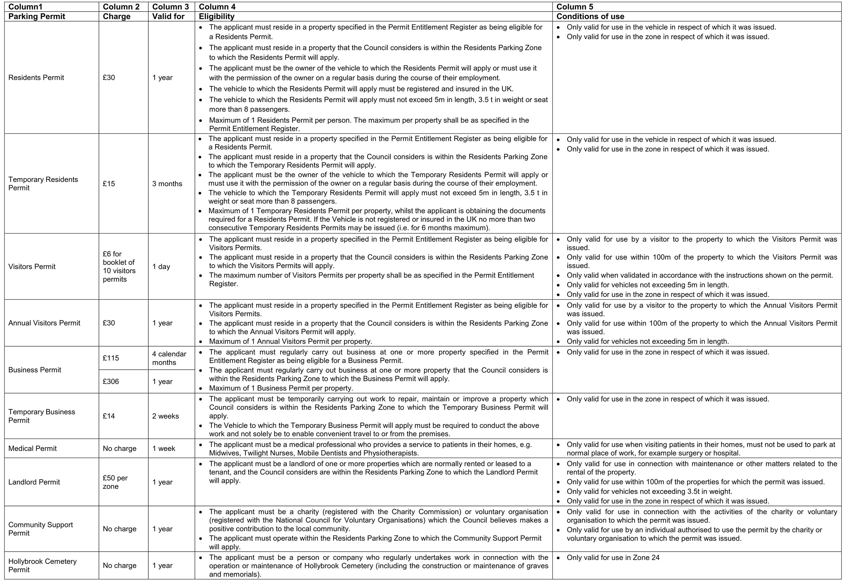

Schedule 4 – Plan of order area
This plan can be viewed in a larger format.
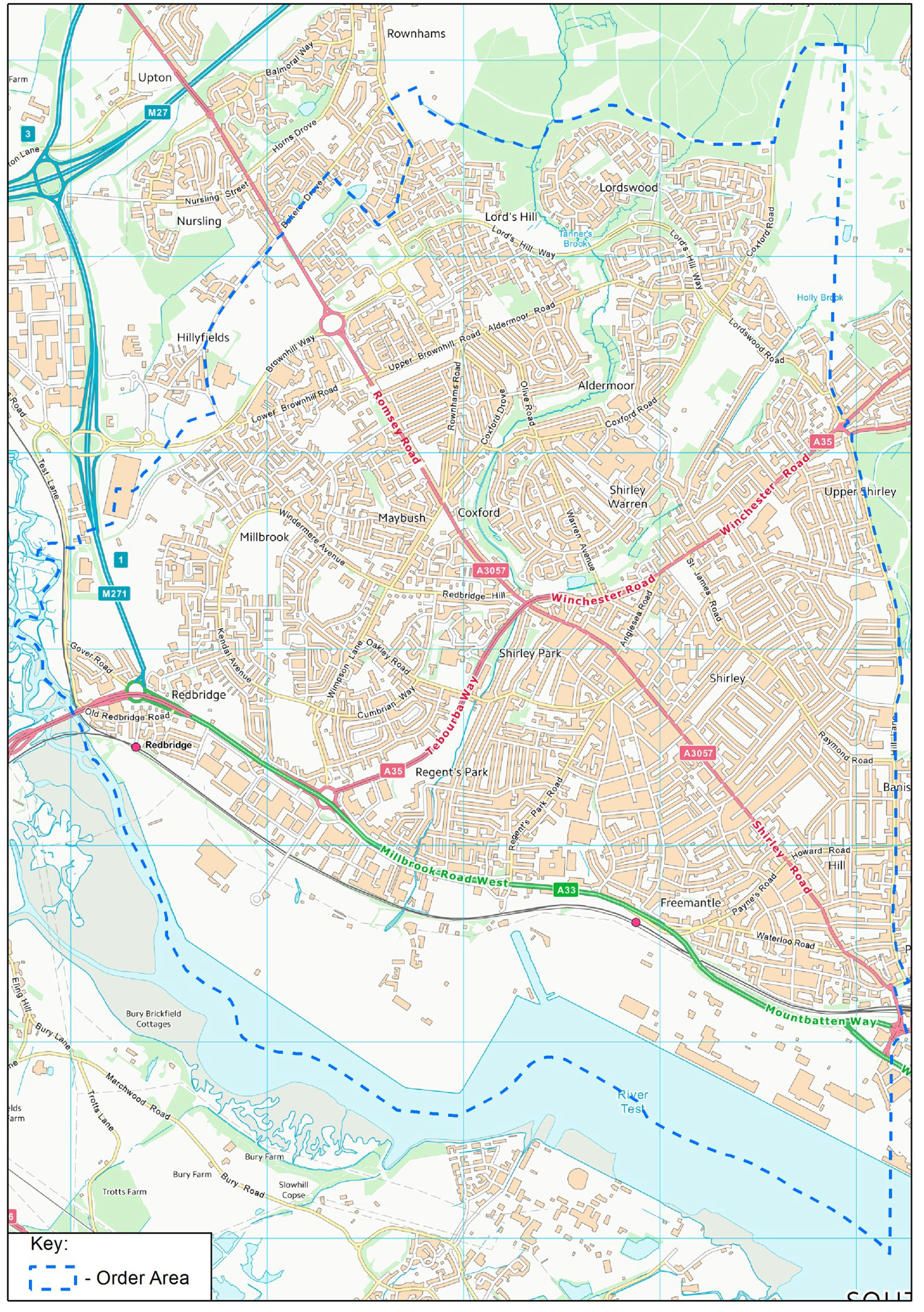
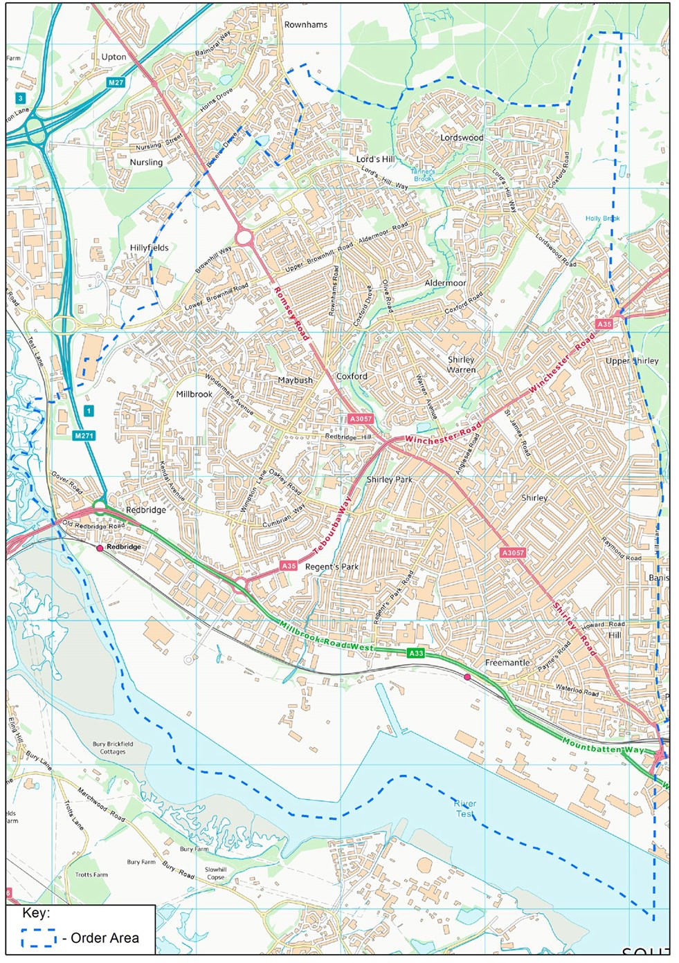
Draft Order - Locator Plan
To view in detail each area covered by the draft order, identify the map tile numbers you require and request copies from Southampton Highways by emailing southamptonRPS@balfourbeatty.com or by phone on 023 8079 8027.
This plan can be viewed in a larger format.