What is happening?
The St Mark’s C of E School was identified for expansion to help provide an additional 900 secondary school places, towards the forecasted demand for an additional 1,500 places overall.
The expansion of St Mark’s will create the first ‘All Through School’ in Southampton providing education from nursery to Sixth Form. The expanded school will also include new sports facilities, which will be centrally located and serve both the primary and secondary pupils.
The expansion project received planning permission in February 2020 and construction started summer 2020.
When complete, the new school will be accessed using the existing entrances on Weston District Cut (for the nursery and primary school), Malmesbury Place (staff car parking, coach access, and cycle parking), and Shirley Road (main administrative & disabled entrance, and secondary school). Access to the sports facilities will be from Stafford Road. The new site will see the number of car parking spaces expand from 34 to 55, in line with requirements set out in the SPD Parking Standards, plus the provision of 274 cycle parking spaces.
The expansion project is expected to be complete late 2022.
For the latest information on the school build visit the dedicated website: www.stmarksproject.com
How will the new school site be accessed?
St Mark’s will be accessed using the existing entrances on Weston District Cut (for the nursery and primary school), Malmesbury Place (staff car parking, coach access, and cycle parking), and Shirley Road (main administrative & disabled entrance, and the secondary school). Access to the Sports facilities will be from Malmesbury Place and Stafford Road.
The new school will have 274 cycle and scooter parking spaces and 55 car parking spaces.
More details of the new access arrangements are available here
Has an assessment been undertaken on the impacts of the larger school?
As part of the approved planning application a Transport Assessment was carried out. This was done to understand the impacts that the larger school would have on the surrounding streets.
More information on the planning application is available here.
What measures have been delivered to make it safe for people to get to St Mark's School
With the larger school there will be more pupils and staff coming and making journeys there. To make their journeys to school as safe as possible and encourage them to be made by walking, cycling, scooting or public transport, we have delivered a package of transport improvement measures, including:
- Continuous footways across Stafford Road, Suffolk Avenue, Cawte Road and Dyer Road, including new planting;
- A new Zebra crossing on Howard Road near Suffolk Avenue;
- A new pedestrian crossing to the north of Cawte Road and Western District Cut; and
- A new parallel zebra crossing connecting to the south of Malmesbury Road and Dyer Road.
There are also plans to construct a continuous footway across the junction of Malmesbury Road with Shirley Road once the school construction works are complete.
These measures were identified through the planning process and developed with the local community.
Consultation and engagement on further measures is expected to be undertaken in Summer 2022.
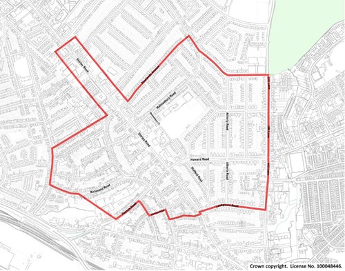
What is an Active Travel Zone (ATZ)?
An ATZ seeks to develop neighbourhoods where it is easier and safer to move around for everybody – whether they are on foot, have mobility restrictions, or on a bike. This is done by reducing through traffic creating new, attractive and safe streets for people. Only traffic that is going into an area will be able to.
The St Mark’s ATZ is shown on the map, and potential measures in St Mark’s ATZ could include:
- Improvements to footways particularly where they cross a road;
- New facilities for people cycling including cycle parking and routes;
- Filters or restrictions to stop through traffic such as partial road closures or banning turns;
- Lower speed limits; or
- Timed closures such as the start and end of the school day.
An ATZ is developed in partnership with people in the local community including residents and businesses. From this process a package of agreed measures are identified and then implemented.
Where is the funding coming from?
The St Mark’s C of E School expansion scheme includes a £350,000 contribution to fund the identified measures listed.
Additional funding from the Government’s Active Travel Fund will be used to start to deliver the Active Travel Zone.
Who will be delivering the transport measures?
The works will be developed and delivered by the Council’s strategic highways partner - Balfour Beatty Living Places. This will be done in partnership with Faithful and Gould, who have been appointed to oversee a citywide school expansion programme, and Morgan Sindall, who are building the expanded St Mark’s C of E School.
More information on the school build is available on the dedicated website.
What other support is being offered to the school?
St Mark’s C of E School is actively engaged in the national accreditation scheme – Modeshift STARS, which recognises excellence in encouraging sustainable travel to school. As part of this programme, the Council has been supporting the school to deliver a range of transport initiatives aimed at encouraging walking, cycling and public transport use. They are expected to achieve their Gold award in the next year.
New initiatives aimed at pupils attending the nursery and secondary school will also be included as part of the supporting package of measures and the new School Travel Plan.
How can I keep up-to-date on the development of the St Mark’s School transport package?
You can sign up to keep up-to-date on the latest information via email on the St Marks ATZ scheme by clicking here and adding your email address.