Summary
- Where: St Mark's School and surrounding area.
- When: November 2020 onwards.
- What: Transport and highways improvements to support St Mark's School expansion including an Active Travel Zone
- Why: To create a greener and more sustainable school community for everyone by identifying and making some small changes to the streets and roads around St Mark's School that will enable travel actively and minimise private car use.
Latest News
January 2023
A range of measures to support the expansion of St Mark’s CE School have been completed. These include the new crossings on Howard Road and Shirley Road, continuous crossings with Cawte Road, Dyer Road, Stafford Road and Suffolk Avenue.
We have asked people what they think of these recent changes by completing the survey at https://soton.cc/st-marks.
The survey was open for 4 weeks until 27 February and the results will be shared on this page.
More information about walking and cycling improvements to Howard Road and Shirley Road can be viewed at the foot of the page.
You can also subscribe here to receive project updates.
Consultation on the scheme
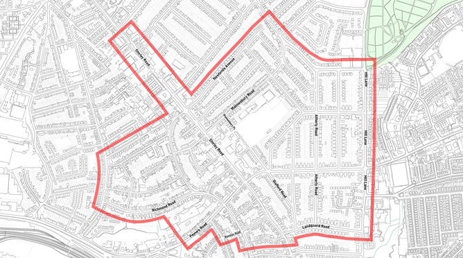
The map above shows the consultation area that the council engaged with over plans to make the area around the school an Active Travel Zone that was safer for walking and cycling and deterred through traffic. The consultation began with a perception survey at the start of 2021, the outcomes were shared and residents were invited to workshops to help co-design solutions. The initial proposals were shared online and through a leaflet sent to everyone in the consultation area and residents were invited to local drop in events to share their thoughts. Changes were formally proposed and consulted on in the summer. You can see the details from each of the consultation processes by clicking on the link tile below.
Project timeline

Project details
St Mark’s C of E School is a primary school located on Shirley Road and currently has capacity for 420 pupils. The school has been identified for expansion to help meet that need for additional school places across the city. The St Mark’s expansion project received planning approval in February 2020 and will provide an additional 900 secondary school places, creating a new an ‘All Through School’ providing education from nursery to Sixth Form on the site, along with sports facilities to the rear on part of the of Services Playing Fields.
St Mark’s C of E School is within in a 20-minute walk of over 13,000 households. Around 65% of pupils currently walk, cycle or scoot to the primary school and 12% use public transport. However, the area suffers from a high volume of cut-through driving. With the extra trips that the additional school places will create, there is a requirement to deliver measures to improve transport and travel in the local area. The council is proposing to achieve this through the delivery of a new Active Travel Zone in partnership with the local community.
We are undertaking engagement with the local community to understand what improvements could be made to the area. We firmly believe that the best ideas always come out of the community and invite you to share your thoughts and suggestions by taking part in our perceptions survey. All feedback received will help to closely inform our plans for the area as these continue to be shaped and developed over the coming months.
Click here for more details on the scheme and how we'll be engaging on our proposals
What is an Active Travel Zone?
An Active Travel Zone seeks to develop a neighbourhood so it is easier to move around on foot or by cycling by reducing and removing traffic and creating an attractive and safe environment. Measures could include restrictions to motor vehicles which seek to create a more attractive environment for pedestrians and cyclists by removing through traffic, reducing speeds, reallocating road space and creating healthier communities. An Active Travel Zone is developed in partnership with the local community.
