Summary
- Where: Winchester Road, between Thornhill Road and Bassett Avenue
- When: We are currently developing the designs for the scheme, and consulting with the local community. Our aim is to then begin construction in Autumn 2026
- What: We are making it easier and more enjoyable for people to walk, wheel and cycle in the area around the Outdoor Sports Centre with new and upgraded pedestrian crossings and safer protected cycle lanes. We will also be resurfacing Winchester Road, and upgrading dropped crossings and bus stops to current standards
- Why: Local people have told they want Winchester Road to be safer and more comfortable to cross and travel along. This supports our plans to create better places to walk and cycle in across Southampton. We ran a survey in April 2026 and across all parts of the proposals an average of 64% of the replies were supportive
- How: Using a combination of funding from the Outdoor Sports Centre project and the Local Transport Plan
The public consultation on this scheme is currently open. Click here to have your say.
Project Details
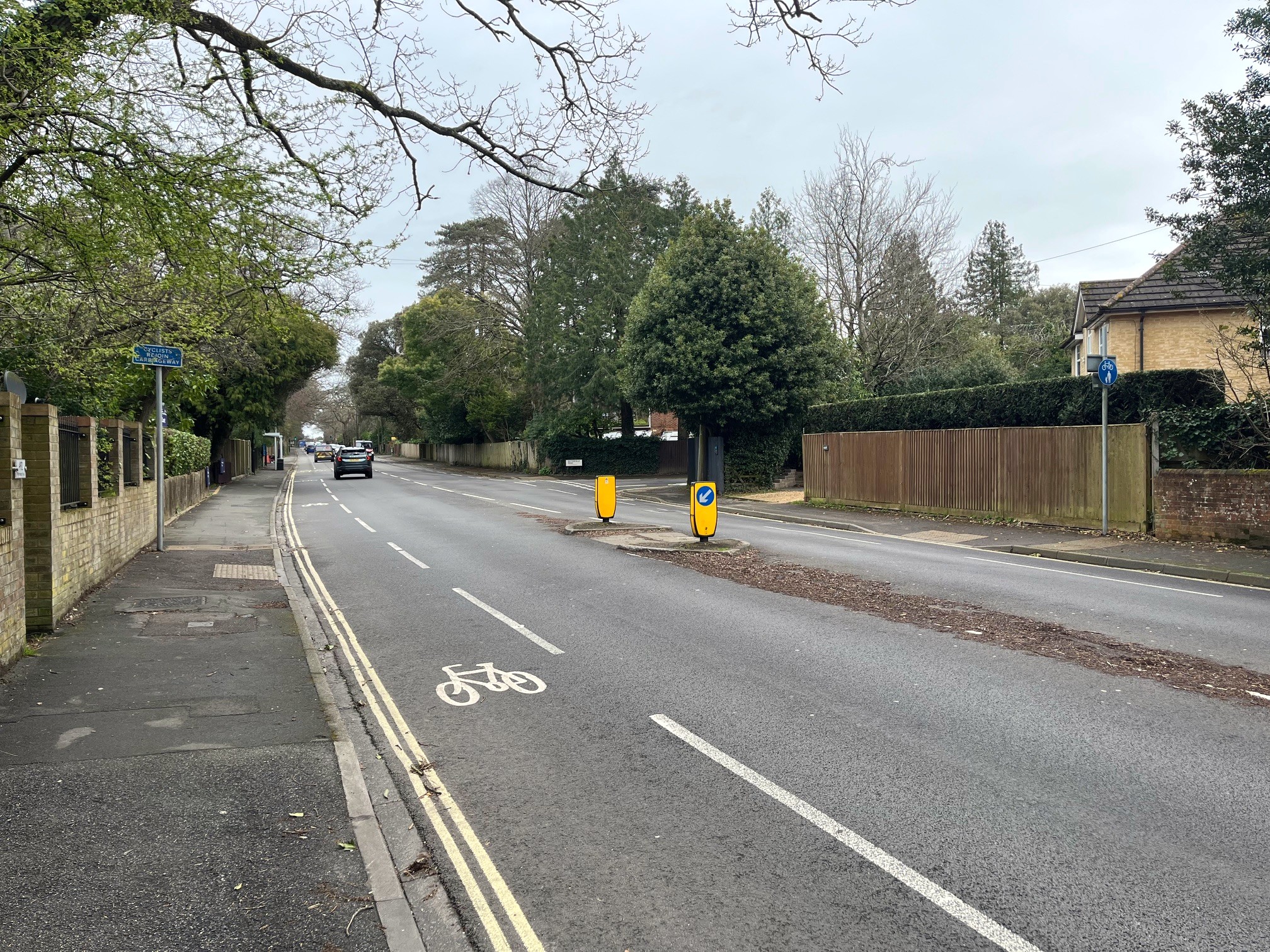
We want to make it easier, safer and more enjoyable for people to walk, wheel (i.e. travelling that uses the pavement space at a similar speed to walking, such as using wheelchairs and mobility scooters. It does not include the use of e-scooters or bicycles) and cycle in Southampton. We found that people think Winchester Road is an unattractive place to walk, wheel or cycle and that it is hard to cross. This scheme aims to improve the area and create a more welcoming environment for people. We will do this by:
- Building two new signalised crossings, one at Thornhill Road and one at Butterfield Road, to make it easier and safer to cross the road.
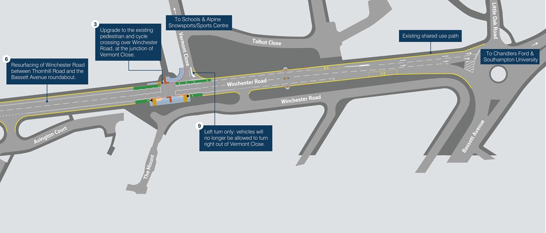
- Upgrading the crossing at Vermont Close to make it safer for people cycling.
- Widening the existing cycle lanes and installing protective bollards where possible, with a similar design to the one we used on St Denys Road.
- Upgrading bus stops, to include accessible kerbing and real-time information screens at all stops.
- Resurfacing Winchester Road between Thornhill Road and Bassett Avenue to reduce road noise and improve safety.
- Introducing a left-turn only restriction for vehicles leaving Vermont Close to improve traffic flow.
- Improving dropped crossings in surrounding side streets to support people walking and wheeling.
- Supporting access and road safety by introducing some additional double yellow lines
Responses and changes from the April 2026 survey
In the April 2026 engagement survey, we heard that local residents are generally supportive of the scheme but have concerns about a few elements of it. Overall an average of 64% of responses were supportive, and 61% of people thought that the changes would make walking, cycling and wheeling easier around Winchester Road.
Please see the table below for our responses to some of the most common suggestions we received.
| Your feedback | Our response | Changes to scheme? |
| Vermont Close Junction: There are problems for both cyclists and vehicles trying to make right turns here, especially considering the new school extension at Great Oaks. | Following discussions with Great Oaks School, and a review of the vehicle traffic predicted from its expansion, we have decided to propose a left-turn only restriction when leaving Vermont Close. This will enable vehicles to leave the area more smoothly which will ease congestion, without significantly lengthening journeys. To head west along Winchester Road, people driving will now need to turn left and then make a U-turn at the Bassett Avenue Roundabout before continuing. | Yes |
| Cycle lanes: People who cycle were concerned that that extra width wouldn’t make cycling safer, and people who drive were concerned that the cycle lanes would take up too much road space. |
The previously proposed designs were a compromise that considered the impact of cycle segregation on emergency vehicles that use this corridor. We have had constructive discussions with South Central Ambulance Service, and we believe that we can now introduce segregation on the cycle lanes without disrupting emergency vehicles. The design will be similar to the cycle lanes along St Denys Road. This will create a more comfortable and safer space for people cycling and make the most of the reallocated road space. The traffic lanes will still be wide enough for two buses or HGVs to pass each other comfortably, as well as to allow the safe passage of emergency vehicles. | Yes |
| Direction signage for people walking and cycling. |
We will review where signage is needed along the route to point users towards the new facilities. | Yes |
| Footway conditions. |
We will review the current state of the footways and make repairs or resurface where the budget allows. | Maybe |
| Crossing designs: is shared space the best option? |
Due to the limited space available at all three sites, we have designed the cycle lane to transition into a short section of shared space next to the crossing. This also allows people cycling to use the crossings to make protected right turns, and to remain entirely separated from vehicle traffic. People cycling will also be able to rejoin the traffic lane before this point if they wish to do so. | No |
| Parking opposite Abingdon Gardens preventing continuation of the cycle lane. |
We will investigate this issue further during detailed design. We must keep all users in mind when designing the facility, so any displaced parking will need a suitable alternative. | No |
| Concerns about timing of pedestrian crossings and impact on vehicle traffic. |
The new and upgraded crossings will use sensors which change the traffic lights back to green as soon as someone has crossed or cancels the request if the user walks away. We will also look at whether it will be more efficient for the crossings to activate immediately, or to wait for a gap in traffic. Due to the high volume of traffic along Winchester Road, Zebra crossings would not be suitable for some people, particularly those with disabilities. |
No |
Current proposals
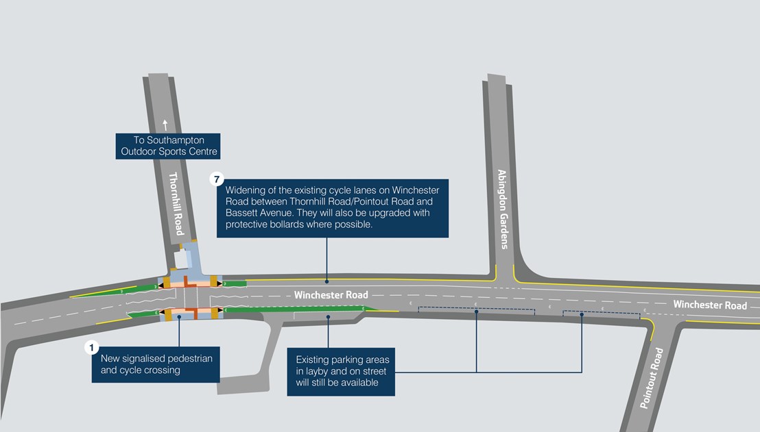
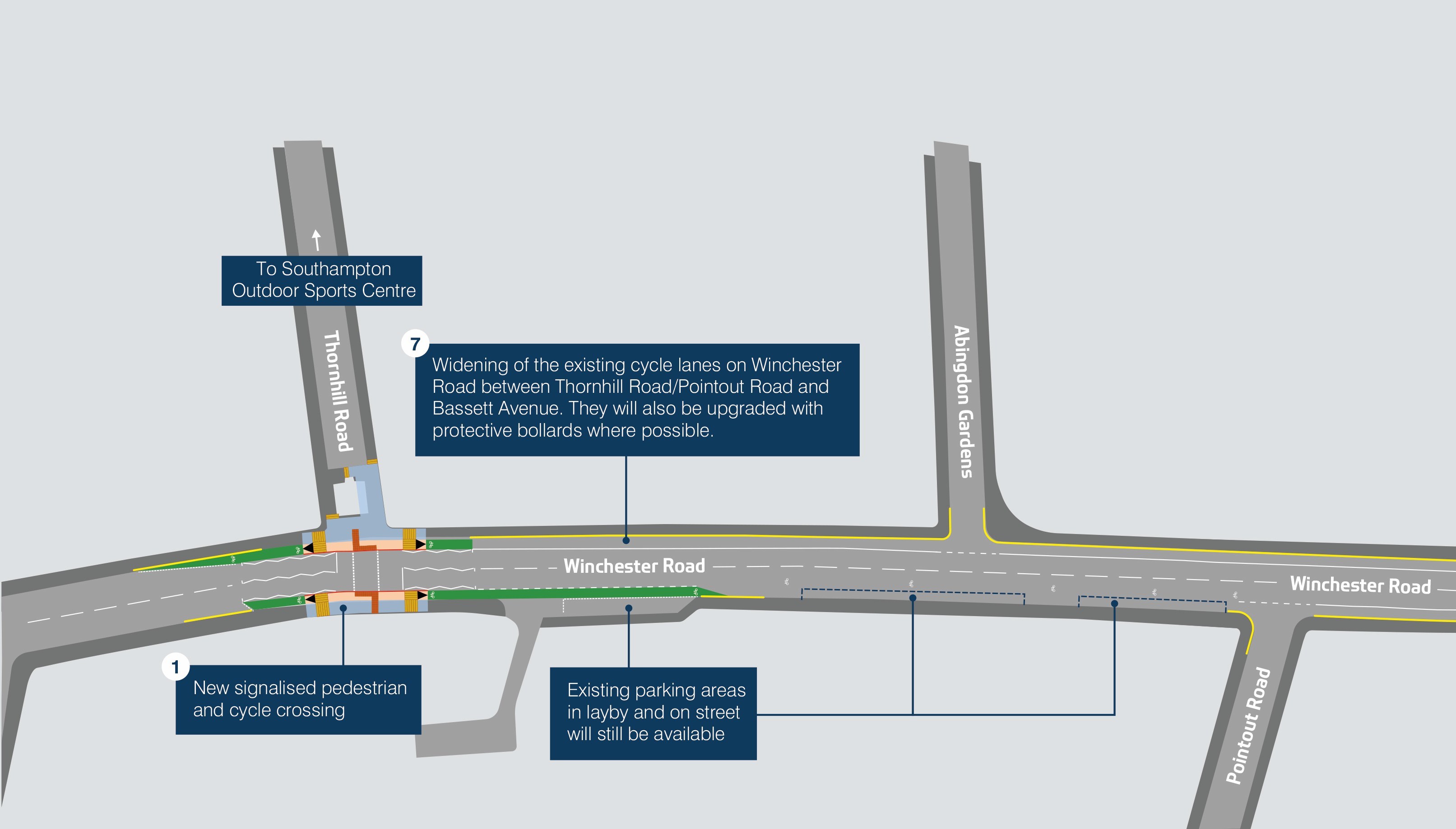
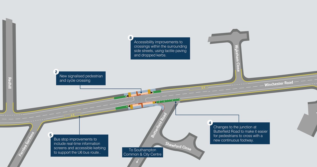
(Open the full plan in a new tab)
The scheme proposals consist of:
- New signalised pedestrian and cycle crossing over Winchester Road, at the junction of Thornhill Road.
- New signalised pedestrian and cycle crossing over Winchester Road, close to the junction of Butterfield Road.
- Upgrade to the existing pedestrian and cycle crossing over Winchester Road, at the junction of Vermont Close.
- Changes to the junction at Butterfield Road to make it easier for pedestrians to cross with a new continuous footway.
- Bus stop improvements to include real-time information screens and accessible kerbing to support the U6 bus route.
- Resurfacing of Winchester Road between Thornhill Road and the Bassett Avenue roundabout.
- Widening of the existing cycle lanes on Winchester Road between Thornhill Road/Pointout Road and Bassett Avenue. Where possible, they will be two metres wide with solid white lines to clearly define the road space, improving safety for all users.
- Accessibility improvements to crossings within the surrounding side streets, using tactile paving and dropped kerbs.
To implement these proposals, we will need to make changes to the on-street parking along Winchester Road. This will only be in the less used areas and where it is required for safety reasons. 9 usable parking spaces will be restricted with double yellow lines, bus stop markings or crossing zigzags. 5 of these are surrounding the new Thornhill Road crossing, and 4 of are located near to Fernlea Gardens. Further details of the changes are available on the Traffic Regulation Order (TRO) consultation page.
Respond to the July 2026 TRO Consultation
To have your say on these proposals you can respond to the Traffic Regulation Order (TRO) consultation. This is likely to be the last round of public consultation and will allow us to legally implement the proposed changes once it is complete.
Click here to respond to the TRO consultation.
Next steps for the scheme
Once the consultation period is finished, we will review the responses and respond to any objections individually.
On the current timeline, we would aim to begin construction of this scheme in Autumn 2026. We will add updates to this page as they are announced, as well as contacting local residents and stakeholders directly.