SCHEME BACKGROUND: What is an Active Travel Zone (ATZ)?
An ATZ is a residential area, bordered by main roads (the places where buses, lorries, non-local traffic should be), where “through” motor vehicle traffic is discouraged or removed. Strategic road closures (like bollards or planters) prevent through traffic and rat running. Every street is still accessible by vehicles.
SCHEME BACKGROUND: Why does Southampton need Active Travel Zones?
Streets in many residential neighborhoods in Southampton are treated as short cuts by drivers avoiding main roads. This traffic often dominates, as vehicles take priority over all other road users and residents, and drivers using it as a shortcut may be more likely to speed. In some streets, traffic data and residents report speed and volumes are at unacceptably dangerous levels, making active travel scary, streets noisy and unattractive and making it hard for neighbours and children to socialize.
SCHEME BACKGROUND: Where is the funding coming from?
This funding comes from the Department of Transport’s Transforming Cities Fund. In March 2020, Southampton City Council, in partnerships with Hampshire County Council, was awarded £57M to deliver an ambitious package of transport improvements. The full bid is available here.
As this is grant funding, it has to be used specifically for an Active Travel Zone and can’t be used for other transport schemes or other council services.
SCHEME BACKGROUND: How was St Denys chosen?
We worked with a data specialist to identify residential areas across the city that would benefit from an ATZ. This process looked at the layout of the streets and local amenities and whether the measures which could be added as part of an ATZ would help more residents walk and cycle. The process also looked at the likely benefit that an ATZ would have on congestion, safety, health and wellbeing.
SCHEME BACKGROUND: Why does St Denys need an Active Travel Zone?
Residents reported to us that several roads in St Denys have high levels of traffic and that their local streets feel too dangerous to walk and cycle, the environment feels noisy and the air feels polluted.
We also carried out traffic surveys that found that there are high numbers of vehicles using some of the residential roads.
SCHEME DEVELOPMENT: How did you decide which measures were proposed for St Denys? What consultation has there been with residents?
All St Denys residents were invited to complete the Your St Denys Your Say survey in December 2019, to identify what you like and don’t like about your neighbourhood. We received nearly 1000 contributions and the key concerns were traffic, safety and air quality.
In February and March, we held four co-design workshops, which were attended by over 100 St Denys residents who worked with our engineers to develop ideas and find solutions to those key concerns. The feedback from the survey and suggestions from the workshops were then analyzed by our transport officers to identify the most popular suggestions. Our engineers also looked at which of those suggestions could be put in place, considering the budget, road widths, and other constraints. Detail on what was and wasn’t taken forward can be found in these pages.
SCHEME DEVELOPMENT: Where can I see the results of surveys and workshops?
To see the contributions to the Your St Denys Your Say survey go to connectingstdenys.commonplace.is
A summary of the results of the ‘Co-designing St Denys’ workshops can be viewed online at connectingstdenysproposals.commonplace.is
SCHEME DEVELOPMENT: When and where can I see the final designs?
All the proposals are currently undergoing full cost analysis and detailed design. When this process is completed the designs can be seen. Early illustrations of what the measures will look like are on this map.
SCHEME DEVELOPMENT: When will I see these measures built?
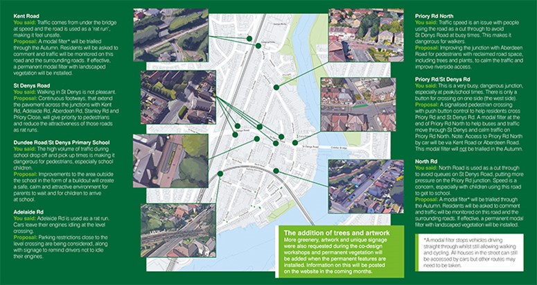
The temporary modal filters are currently planned to be installed in the early autumn (October) on Kent and North Road. They will be reviewed after 6 months.
We will install the other measures over the next 10 months, the first measures are currently planned to be installed in December. The exact timings for when and what will go in where will be dependent on a number of different factors including: the next phase of cost analysis, detailed design and formal consultation from residents. Dates will be added to the website when available and residents directly affected will be contacted by post.
SCHEME DEVELOPMENT: What consideration has there been about people living with a disability or additional mobility needs?
An Equality and Safety Impact report was completed for the proposals and the varying potential impact on different disability groups was considered. Evidence shows that measures to promote walking and cycling benefit people with mobility needs. Specific measures will make it easier to walk, use modified bicycles / tricycles, and mobility scooters to travel around the area. In addition, no access to properties will be prevented if people chose to drive – the scheme will only prevent cars from using residential streets as a through route.
MODAL FILTERS: Why are the modal filters temporary initially? What happens if they don’t work or cause problems for surrounding roads?
The modal filters will be installed temporarily in autumn 2020 so that we can monitor whether they achieve their aim of creating safer, less polluted, calmer streets.
Once the filters are installed, formal consultation with residents will start and residents will have 6 months to formally provide feedback on whether they should remain in place.
During this period, staff will also monitor the traffic makeup (cars, vans, pedestrians and bikes) speed and volumes on Kent Road, North Road, Priory Road North and the surrounding streets. Residents will be asked to complete surveys about their experiences living and using the streets as the changes are added.
MODAL FILTERS: Will the closure of Kent Road lead to more commercial vehicles on Kent Road?
We will monitor traffic conditions on Kent Road during the trial period. The Kent Road filter will mean that commercial vehicles will no longer be able to travel under the bridge. Data collected in Autumn 2019 suggests however that a greater number of commercial vehicles were using this route as a through route rather than the numbers leaving the Industrial estate and as such there will be an overall reduction of commercial traffic in the area.
MODAL FILTERS: I am concerned that the location of the modal filters will impact how I turn out and into the side roads in St Denys.
We will review the existing ‘Keep Clear’ markings at junctions on St Denys Road, and where appropriate will add them to other junctions along the corridor.
Keep clear road markings are placed at areas on the highway to advise drivers to not stop or park within the two lines of the keep clear marking. They are used to keep the flow of traffic resuming and can often be seen at side roads that lead off from a busy main road.
MODAL FILTERS: I am concerned about the location of the modal filter on North Road.
The North Road modal filter will be designed as a trial, so that it can be easily modified if early observations indicate alterations are required. The proposed position, between Stanley Road and Priory Road, takes into account factors such as alternative access options, impact on waste collection vehicles and the national cycle route on Priory Road.
MODAL FILTERS: I am concerned that the modal filters will result in increased traffic levels in other side roads, such as South Road or Aberdeen Road.
The modal filters will be designed as a trial, so that they can be easily modified if early observations indicate alterations are required. Whilst some side roads may see an increase in local traffic, St Denys will benefit from a reduction in vehicles using streets as a through route. Traffic levels on alternative routes like South Road and Aberdeen Road will be monitored during the trial.
MODAL FILTERS: Why can’t cameras be used to restrict access for non-residential cars as an alternative to the Kent Road modal filter?
Local authorities outside of London are not currently able to use Civil Enforcement powers (including automatic number plate recognition) against traffic offences such as driving through a resident only zone.
CONTINUOUS CROSSINGS: What is a continuous crossing?
A continuous crossing describes a junction layout where a side road joins a major road, i.e. a priority junction, at which the footway along the major road continues across the junction mouth uninterrupted with the same (or visually similar) surfacing treatment. There is no kerb edge or tactile paving indicating a change of function.
CONTINUOUS CROSSINGS: How does a continuous crossing work?
Continuous crossings aim to improve safety for pedestrians and cyclists by giving them priority at the road junction and changing the behaviour of drivers and vehicles.
There are a number of factors that influence a driver’s behaviour as it approaches a junction including the volume of pedestrians, give way lines set behind ramped continuous crossing, the depth of the continuous crossing, sightlines and traffic speed approaching the junction.
CONTINUOUS CROSSINGS: What evidence is there to support continuous crossings?
Behaviour changes take time to bed in but there is good evidence to suggest continuous crossings are effective in influencing driver actions. Continuous crossings are a common feature in the Netherlands and are being implemented across the UK.
Steer Davies Gleave conducted a study on behalf of Transport for London (TfL), among their findings they stated that:
- Drivers are more likely to give way to pedestrians who are on or very near the continuous footway.
- A majority of drivers give way to cyclists who are using the main road. 97% of drivers gave way to cyclists who are level or ahead on the carriageway.
- Drivers are more likely to give way to pedestrians when pedestrian volumes are higher. This pattern interacts with junction type, which appears to play a key role in whether or not drivers are more likely to give way.
- A ramp and give way lines set behind the continuous footway appear to encourage drivers to slow and stop before the continuous footway. However, at very deep footways drivers are less likely to stop at the give way markings behind the footway
Overall, the study found that continuous crossing reduce risk for pedestrians and cyclists.
CONCERNS: I am concerned about access for delivery vehicles, emergency vehicles or larger vehicles.
The Southampton City Council waste services team have been fully consulted on the proposals and are happy that there will be ample space for their vehicles to access the area. The scheme is designed to maintain access to all properties by private, commercial and emergency vehicles but prevent cars from using residential streets as a through route. As part of the engineering process, engineers and transport planners review The designs to ensure the emergency services can still access all the properties.
CONCERNS: I am concerned that by reducing traffic volumes crime and anti-social behaviour will increase under the Kent Road Bridge.
We are investigating the inclusion of improved lighting under the bridges, as well as CCTV and landscaping features within the permanent designs.
CONCERNS: Will I still be able to travel by car to my house?
Every residential property will still be accessible by car, by the emergency services, by delivery vehicles and refuse trucks, although some residents may have to take a slightly longer route.
CONCERNS: I am concerned that the proposal doesn’t address other issues I experience when travelling by car or by bike locally, such as traffic light phasing, road surfacing or congestion on Thomas Lewis Way?
The funding we have received for this project is exclusively for the creation of an Active Travel Zone. Some additional issues will be addressed as part of a wider package of works funded by the Transforming Cities Fund, such as improvements to Thomas Lewis Way and Portswood. These can be viewed on our Connected Southampton website www.transport.southampton.gov.uk
SCC has a list of schemes in St Denys which are currently unfunded, such as road resurfacing. We will be reviewing budgets and if funding savings are made in the delivery of the Active Travel Zone we will look to carry out additional works in the area.
Our long term ambitions for transport across the city can be found on our Connected Southampton page here: www.transport.southampton.gov.uk/connected-southampton-2040.
CONSULTATION: Will non-St Denys residents be able to object/comment on the scheme? How are objections weighted?
Traffic regulation order (TRO) proposals made by SCC are public consultations and any member of the public, whether a resident here or from another county, are encouraged to make a representation regarding the proposals if they choose to. All responses are treated equally, and issues raised are considered on their individual merits with no weight given to any person, group or association.
CONSULTATION: I am still very unhappy with the scheme, how can I formally object?
The trial modal filters will be implemented using an experimental traffic regulation order (ETRO). During the first six months, residents will be able to officially comment on the schemes through this legal process. Further details on how to do this will be sent separately to residents.
CONSULTATION:I am concerned that I have had no opportunity to object prior to the modal filters being trialled.
Experimental traffic orders are part of the decision-making process and will allow us to trial the modal filters in a live situation. This is a key part of the consultation process. All residents will have the opportunity to officially comment on the schemes during the first six months of the trial.
OTHER: How will you take account of COVID-19?
We have considered the impact Covid-19 might have on the traffic data we collect. Traffic measurements collected in autumn 2019 show us what traffic speed and volumes were in St Denys were like pre-COVID-19. When we evaluate the trials we will use this alongside other more recently collected travel data collected from across the city for context.
OTHER: Why are trees and art included? Do the benefits outweigh a reduction in parking, a change in sight lanes for cars?
The inclusion of trees in schemes such as the St Denys Active Travel Zone has benefits for human health, biodiversity, a sense of community/place and in some cases has increased property prices.
Trees remove pollutants from the air, improving opportunities for nature, and shrubs can provide a network of biodiversity corridors. As we see the impacts of climate change and summers get warmer the shade provided by trees in residential streets will be an important point of shelter for residents on foot.
During the co-design workshops both trees and art were recommended for inclusion by residents. Discussions will be held with local community groups already working hard to create a greener St Denys to identify how we can work collaboratively on these plans.
OTHER: Can a cross hatching box be added to St Denys Road?
Southampton City Council has a preference, as per the guidance, to limit yellow box junctions to signalised crossings, and use KEEP CLEAR markings at side road junctions.
We will review existing ‘Keep Clear’ markings at junctions on St Denys Road, and where appropriate will add them to other junctions along the corridor.
Keep clear road markings are placed at areas on the highway to advise drivers to not stop or park within the two lines of the keep clear marking. They are used to keep the flow of traffic resuming and can often be seen at side roads that lead off from a busy main road that typically has traffic congestion.